geo.wikisort.org - Mountains
Jebel Barkal or Gebel Barkal (Arabic: جبل بركل) is a mesa or large rock outcrop located 400 km north of Khartoum, next to Karima in Northern State in Sudan, on the Nile River, in the region that is sometimes called Nubia. The jebel is 104 m tall, has a flat top, and came to have religious significance for both ancient Kush and ancient Egyptian occupiers. In 2003, the mountain, together with the extensive archaeological site at its base (ancient Napata), were named as the center of a World Heritage Site by UNESCO. The Jebel Barkal area houses the Jebel Barkal Museum.
جبل بركل | |
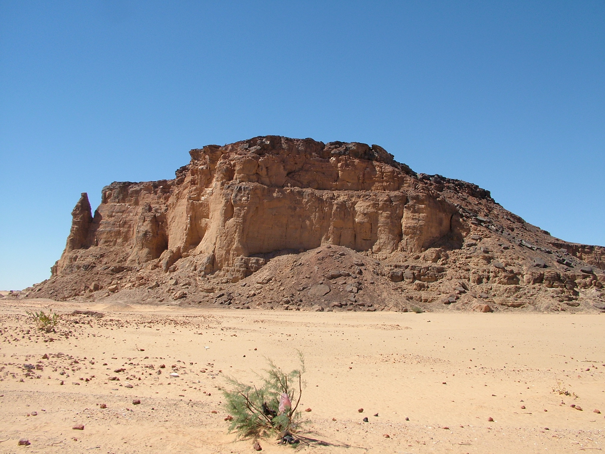 Jebel Barkal is a small mesa (104 meters tall) | |
 Jebel Barkal Shown within Northeast Africa  Jebel Barkal Jebel Barkal (Sudan)  Jebel Barkal Jebel Barkal (Africa) | |
| Alternative name | Gebel Barkal |
|---|---|
| Location | Karima, Northern State, Sudan |
| Region | Nubia |
| Coordinates | 18°32′12″N 31°49′42″E |
| Type | Sanctuary |
UNESCO World Heritage Site | |
| Official name | Gebel Barkal and the Sites of the Napatan Region |
| Type | Cultural |
| Criteria | i, ii, iii, iv, vi |
| Designated | 2003 (27th session) |
| Reference no. | 1073 |
| Region | Arab States |
History
The earliest occupation of Jebel Barkal was that of the Kerma culture that was also known as Kush, but this occupation is so far known only from scattered potsherds.
Around 1450 BCE, the Egyptian Pharaoh Thutmose III conquered Barkal and built a fortified settlement (Egyptian menenu) there as the southern limit of the Egyptian empire. The city and region around it came to be called Napata, and the Egyptian occupation of Jebel Barkal extended through most of the New Kingdom of Egypt. The Egyptians built a complex of temples at the site, centered on a temple to Amun of Napata—a local, ram-headed form of the main god of the Egyptian capital city of Thebes, Egypt. In the last years of the New Kingdom and after its collapse in 1169 BC, there was little construction at Jebel Barkal. Apart from the temples, no trace of this Egyptian settlement has yet been found at the site.
![Statue of Pharaoh Taharqa from Jebel Barkal (3.6 meters). National Museum of Sudan.[1]](http://upload.wikimedia.org/wikipedia/commons/8/80/SNMTaharqo.jpg)
Jebel Barkal was the capital city of the Kingdom of Kush as it returned to power in the years after 800 BCE as the Dynasty of Napata. The Kushite kings who conquered and ruled over Egypt as the 25th Dynasty, including Kashta, Piankhy (or Piye), and Taharqa, all built, renovated, and expanded monumental structures at the site.
After the Kushites were driven out by the Assyrian conquest of Egypt in the mid-7th century BC, they continued to rule Kush with Jebel Barkal and the city of Meroë as the most important urban centers of Kush. Jebel Barkal's palaces and temples continued to be renovated from the 7th-early 3rd centuries BC. Most of the royal pyramid burials of the kings and queens of Kush during this time were built at the site of Nuri, 9 km to the northeast of Jebel Barkal.
In 270 BCE, the location of Kushite royal burials was moved to Meroë, inaugurating the Meroitic period of the Kingdom of Kush. Jebel Barkal continued to be an important city of Kush during the Meroitic period. A sequence of palaces were built, most notably by King Natakamani, new temples were built and older temples were renovated. During the 1st century BC - 1st century AD, eight royal pyramid burials were built at Jebel Barkal (rather than at Meroë), for reasons that are not clear, but perhaps reflecting the prominence of one or more families from the city.
After the collapse of Kush during the 4th century AD, Jebel Barkal continued to be occupied in the medieval (Christian) period of Nubia, as attested by architectural remains, burials, and burial inscriptions.
Temples


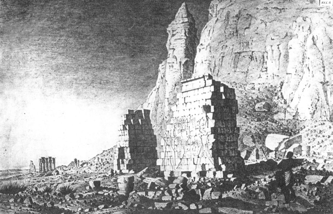
The ruins around Jebel Barkal include at least 13 temples that were built, renovated, and expanded over a period of over 1,500 years. The temples were described for the first time by a series of European explorers beginning in the 1820s. Their drawings and descriptions, particularly those of Frédéric Cailliaud (1821), Louis Maurice Adolphe Linant de Bellefonds (1821), and Karl Richard Lepsius (1844), record significant architectural details that have since disappeared. In 1862 five inscriptions from the Third Intermediate Period were recovered by an Egyptian officer and transported to the Cairo Museum, but not until 1916 were scientific archeological excavations performed by a joint expedition of Harvard University and the Museum of Fine Arts of Boston under the direction of George Reisner.[2] From the 1970s, explorations continued by a team from the University of Rome La Sapienza, under the direction of Sergio Donadoni, that was joined by another team from the Boston Museum, in the 1980s, under the direction of Timothy Kendall.
Temple of Amun and Temple of Mut
The larger temples, such as the Temple of Amun, are even today considered sacred to the local population. The carved wall painted chambers of the Temple of Mut are well preserved.
 The last standing pillars of Napata's temple of Amun at the foot of Jebel Barkal
 Stone statue of a ram
 Lion-headed God Appademak with Pharaoh Taharqa (right) in the Jebel Barkal Temple of Mut.
 Taharqa, followed by the sistrum shaking queen Takahatenamun in the Jebel Barkal Temple of Mut.


Temple B700 at Jebel Barkal
Temple B700, built by Atlanersa and decorated by Senkamanisken, is now largely destroyed.[3] It received the sacred bark of Amun from the nearby B500 on certain cultic occasions, and may have served during the coronation of the kings of the early Napatan period, in the mid 7th century BC. The Temple was decorated by Senkamanisken, where he is shown clubbing enemies.[3]
The hieroglyphic inscription on the Temple described the role of the god Amun in selecting Sekamanisken as king:
I said of you [while you were still] in your mother's womb that you were to be ruler of Kemet ["Black Land", probably meaning Egypt and Kush]. I knew you in the semen, while you were in the egg, that you were to be lord. I made you receive the Great Crown, which Re caused to appear on the first good occasion. [Inasmuch as] a father makes his son excellent, it is I who decreed kingship to you. [So] who shall share it with you? For I am the Lord of Heaven. As I give to Re, [so] he gives to his children, from gods to men. It is I who gives you the royal charter.... No other [can] decree (who is to be) king. It is I who grants kingship to whomever I will.
— Amun inscription, frieze of Sekamanisken, Temple B700, Jebel Barkal.[4]
 Ruins of Temple B700 of Jebel Barkal with relief of Senkamanisken clubbing enemies, drawn in 1821 by Louis Maurice Adolphe Linant de Bellefonds
![Senkamanisken slaying enemies in front of God Amun, at Jebel Barkal (pylon of building B 700, west of the main temple).[5]](//upload.wikimedia.org/wikipedia/commons/thumb/b/bd/Senkamanisken_slaying_enemies_at_Jebel_Barkal.jpg/158px-Senkamanisken_slaying_enemies_at_Jebel_Barkal.jpg) Senkamanisken slaying enemies in front of God Amun, at Jebel Barkal (pylon of building B 700, west of the main temple).[5]
Senkamanisken slaying enemies in front of God Amun, at Jebel Barkal (pylon of building B 700, west of the main temple).[5]![Senkamanisken slaying enemies at Jebel Barkal (detail).[6]](//upload.wikimedia.org/wikipedia/commons/thumb/5/50/Senkamanisken_slaying_enemies_at_Jebel_Barkal_%28detail%29.jpg/200px-Senkamanisken_slaying_enemies_at_Jebel_Barkal_%28detail%29.jpg) Senkamanisken slaying enemies at Jebel Barkal (detail).[6]
Senkamanisken slaying enemies at Jebel Barkal (detail).[6]
![Senkamanisken slaying enemies in front of God Amun, at Jebel Barkal (pylon of building B 700, west of the main temple).[5]](http://upload.wikimedia.org/wikipedia/commons/b/bd/Senkamanisken_slaying_enemies_at_Jebel_Barkal.jpg)
![Senkamanisken slaying enemies at Jebel Barkal (detail).[6]](http://upload.wikimedia.org/wikipedia/commons/5/50/Senkamanisken_slaying_enemies_at_Jebel_Barkal_%28detail%29.jpg)
Pyramids

Jebel Barkal served as a royal cemetery during the Meroitic Kingdom.[7] The earliest burials date back to the 3rd century BC.
- Bar. 1 King from the middle of the 1st century BCE
- Bar. 2 King Teriqas (c. 29–25 BCE)
- Bar. 4 Queen Amanirenas ? (1st century BCE)
- Bar. 6 Queen Nawidemak[8] (1st century BCE)
- Bar. 7 King Sabrakamani? (3rd century BCE)
- Bar. 9 King or Queen of the early 2nd century CE
- Bar. 11 King Aktisanes[8] (3rd century BCE)
- Bar. 14 King Aryamani[8] (3rd century BCE)
- Bar. 15 King Kash[...]merj Imen[8] (3rd century BCE)
 Pyramids, next to Jebel Barkal
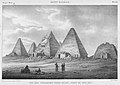 Pyramids at Jebel Barkal in 1821
 Pyramids of Jebel Barkal today
 Pyramids in the southern group


History of Excavation of the Site
Napata’s urban remains have not yet been significantly excavated, but rubble heaps indicate that the area was probably home to major settlement in antiquity. There are no traces of a pre-Egyptian settlement, though this may change as more is uncovered at the site. The earliest buildings found at Napata date from the middle of the eighteenth Dynasty. The first archaeologist to work at the site was George A. Reisner who worked there from 1916-1920 and excavated a number of buildings. His first excavation at Napata was a large Meroitic structure (Named “B 100”) that dated to the first century CE. At first, Reisner assumed this to be an “administrative building”, though it is now known to have been a palace.[9]
Artifacts in Museums
![Colossal statue of King Aspelta from the Temple of Amun, Jebel Barkal. Boston Museum of Fine Arts.[10]](//upload.wikimedia.org/wikipedia/commons/thumb/4/4d/Colossal_statue_of_King_Aspelta_MFA.jpg/49px-Colossal_statue_of_King_Aspelta_MFA.jpg) Colossal statue of King Aspelta from the Temple of Amun, Jebel Barkal. Boston Museum of Fine Arts.[10]
Colossal statue of King Aspelta from the Temple of Amun, Jebel Barkal. Boston Museum of Fine Arts.[10] The Stele of Piye was discovered in Jebel Barkal. Cairo Museum
 The Stele of Tantamani. Cairo Museum
 Golden Bracelet found in the tomb of a member of the Royal Family in Gebel Barkal. Meroitic period, 250-100 BCE
![Barque stand from Temple B700 showing Atlanersa holding up the heavens,[11] now in the Museum of Fine Arts in Boston[12][13][14]](//upload.wikimedia.org/wikipedia/commons/thumb/8/80/Stand_for_a_boat_shrine_of_Amun-Re_3.jpg/120px-Stand_for_a_boat_shrine_of_Amun-Re_3.jpg) Barque stand from Temple B700 showing Atlanersa holding up the heavens,[11] now in the Museum of Fine Arts in Boston[12][13][14]
Barque stand from Temple B700 showing Atlanersa holding up the heavens,[11] now in the Museum of Fine Arts in Boston[12][13][14] Djed amulet, Gebel Barkal, 25th Dynasty. Ânkh-Djed-Ouas (British Museum, EA 54412)


![Barque stand from Temple B700 showing Atlanersa holding up the heavens,[11] now in the Museum of Fine Arts in Boston[12][13][14]](http://upload.wikimedia.org/wikipedia/commons/8/80/Stand_for_a_boat_shrine_of_Amun-Re_3.jpg)

See also
- List of World Heritage Sites in Africa
- Nubian pyramids
- Pyramids at El-Kurru
- Pyramids of Jebel Barkal
- Pyramids of Meroë
- Pyramids of Nuri
- Sedeinga pyramids
References
- Smith, William Stevenson; Simpson, William Kelly (1 January 1998). The Art and Architecture of Ancient Egypt. Yale University Press. p. 235. ISBN 978-0-300-07747-6.
- A. Reisner, "Historical Inscriptions from Gebel Barkal", Sudan Notes and Records, 4 (1921), pp. 59-75
- "Following their expulsion from Egypt by the Assyrians in 661 BC, the Kushites continued to develop the Barkal sanctuary. Atlanersa and Senkamanisken erected the small Temple B 700, which became a royal mortuary temple." Museum, Sudan National. Sudan: Ancient Treasures: an Exhibition of Recent Discoveries from the Sudan National Museum. British Museum Press. p. 160. ISBN 978-0-7141-1960-1.
- Jebel Barkal Guide (PDF). p. 97.
- Jebel Barkal Guide (PDF). pp. 97–98.
- Jebel Barkal Guide (PDF). pp. 97–98.
- László Török, The kingdom of Kush: handbook of the Napatan-Meroitic Civilization
- Welsby, Derek A. (1998). The Kingdom of Kush: The Napatan and Meroitic Empires. Princeton: Markus Weiner Publishers. p. 208. ISBN 1-55876-182-9.
- Kendall, Timothy (2016). A Visitor's Guide to The Jebel Barkal Temples. pp. 10–15.
- "Statue of King Aspelta". collections.mfa.org.
- Kendall, Timothy; Ahmed Mohamed, El-Hassan (2016). "A Visitor's Guide to The Jebel Barkal Temples" (PDF). The NCAM Jebel Barkal Mission. Khartoum: Sudan. Nubian Archeological Development Organization (Qatar-Sudan): 98.
- Reisner 1925, p. 17.
- Barque stand, MFA 2019.
- Barque stand fragments, MFA 2019.
Sources
- Kendall, Timothy. A Visitor's Guide to The Jebel Barkal Temples (PDF).
External links
- Website of the National Corporation for Antiquities and Museums Archaeological Mission at Jebel Barkal
- LearningSites.com - Gebel Barkal
- UNESCO World Heritage Centre - Gebel Barkal and the Sites of the Napatan Region
- Gebel Barkal and the Sites of the Napatan Region UNESCO collection on Google Arts and Culture
- The Victory Stela of Piye
На других языках
[de] Jebel Barkal
Jebel Barkal (arabisch جبل البركل Dschabal al-Barkal, DMG Ǧabal al-Barkal; ägyptisch ḏw wˁb – der reine Berg, auch Gebel Barkal oder Dschebel Barkal, das erste Wort ist jeweils die Transkription für das arabische Wort „Berg“, Barkal bedeutet „heilig“) ist ein kleiner Berg im Norden Sudans mit 287 m Höhe. Der Jebel Barkal ist von einem ausgedehnten Ruinenfeld umgeben, das mehrere Tempelanlagen, bedeutende Profanbauten ("Paläste") sowie eine Pyramiden-Nekropole umfasst. Die Bauten bilden zusammen mit den Funden in Sanam die antike Stadt Napata. Daher erhielten der Berg Barkal, Sanam und weitere Fundstätten der Umgebung 2003 von der UNESCO den Status Weltkulturerbe.- [en] Jebel Barkal
[es] Gebel Barkal
Gebel Barkal o mejor: Ŷébel Barkal (Montaña Pura) es el nombre árabe del que fuera lugar sagrado del reino de Napata, situado en una pequeña montaña de 98 m de altura con una cima plana, no muy lejos y al norte de la ciudad, en el mismo lado oriental del río Nilo. El nombre antiguo no se conoce. Hoy día está en el norte del actual Sudán, a 2 km al sudoeste de la ciudad de Karima.[it] Gebel Barkal
Gebel Barkal in arabo: جبل بركل, Jabal Barkal o Montagna Pura, è un rilievo a circa 400 chilometri a nord di Khartoum, in Sudan, su una larga ansa del Nilo, a ridosso della quarta cateratta. Rappresenta storicamente il limite massimo della penetrazione egizia verso il sud, nel territorio della Nubia, verso il 1450 a.C., con il faraone egiziano Thutmose III. In questo luogo il sovrano fondò la città di Napata che, circa 300 anni dopo, divenne capitale del regno indipendente di Kush.[ru] Джебель-Баркал
Джебель-Баркал (араб. جبل بركل — Dschabal Barkal, древнеегипет. ḏw wˁb — «Священная скала») — скала, высотой в 98 метров в извилине Нила в северной части Судана, носившей в древности имя Нубии.Другой контент может иметь иную лицензию. Перед использованием материалов сайта WikiSort.org внимательно изучите правила лицензирования конкретных элементов наполнения сайта.
WikiSort.org - проект по пересортировке и дополнению контента Википедии