geo.wikisort.org - Mountains
Jírova hora is a hill in the territory of Hronov in the Hradec Králové Region of the Czech Republic. It lies in the Broumov Highlands and has an altitude of 485 m (1,591 ft). It is situated between the villages of Zbečník, Rokytník and Velký Dřevíč.
| Jírova hora | |
|---|---|
 Jírova hora viewed from a park in Hronov | |
| Highest point | |
| Elevation | 485 m (1,591 ft) |
| Coordinates | 50°29′13″N 16°10′32″E |
| Geography | |
 Jírova hora Hronov, Czech Republic | |
| Parent range | Broumov Highlands |
Description
The eastern slope of the hill is very steep. The whole hill is covered mainly by coniferous forest (mainly spruce trees) and meadows. A deciduous forest grows on the southern slope, falling to Zbečník. A part of the forest on the top of the hill and the north slope is formed by young coniferous trees. A very small stream flows from the northern slope, from Rokytník to Velký Dřevíč. On the top of the hill there is a radio communications transmitter. In the western direction from the top of hill, construction of an artillery fort of the Czechoslovak border fortification system was planned prior to World War II.
Gallery
 Aerial view
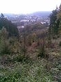 Panorama of Hronov viewed from the top

External links
This Hradec Králové Region location article is a stub. You can help Wikipedia by expanding it. |
На других языках
- [en] Jírova hill
[ru] Йирова гора
Йирова гора находится в северо-восточной Чехии между деревнями: Збечник, Рокытник и Велки-Држевич. Восточной откос горы довольно крутой. Горa покрыта лугами и хвойным лесом, лиственный лес растёт только на южном откосе. Самый молодой древесный покров располагается на северной стороне и местами наверху горы.Другой контент может иметь иную лицензию. Перед использованием материалов сайта WikiSort.org внимательно изучите правила лицензирования конкретных элементов наполнения сайта.
WikiSort.org - проект по пересортировке и дополнению контента Википедии