geo.wikisort.org - Mountains
Iron Mountain is a 6,826-foot (2,081-metre) elevation summit located in the eastern Olympic Mountains in Jefferson County of Washington state.[4] It is set within Buckhorn Wilderness, on land managed by Olympic National Forest. It is situated between Buckhorn Mountain, 0.58 mi (0.93 km) to the southwest, and Mount Worthington, 0.76 mi (1.22 km) to the northeast.[1] Precipitation runoff from Iron Mountain drains south into the Big Quilcene River, and north into Copper Creek which is a tributary of the Dungeness River. Topographic relief is significant as the southeast aspect rises 2,800 feet (853 meters) above the Big Quilcene River in less than one mile, and the north aspect rises 1,700 feet (518 meters) above Buckhorn Lake in one-half mile. Old-growth forests of Douglas fir, western hemlock, and western redcedar grow in the valleys surrounding the peak. The nearest community is Quilcene 11 miles to the east.
| Iron Mountain | |
|---|---|
 Northwest aspect | |
| Highest point | |
| Elevation | 6,826 ft (2,081 m)[1][2] |
| Prominence | 266 ft (81 m)[1] |
| Parent peak | Buckhorn Mountain (6,988 ft)[3] |
| Isolation | 0.30 mi (0.48 km)[3] |
| Coordinates | 47°49′42″N 123°06′36″W[4] |
| Geography | |
 Iron Mountain Location of Iron Mountain in Washington  Iron Mountain Iron Mountain (the United States) | |
| Location | Buckhorn Wilderness Jefferson County, Washington, US |
| Parent range | Olympic Mountains |
| Topo map | USGS Mount Townsend |
| Geology | |
| Age of rock | Eocene |
| Climbing | |
| First ascent | Unknown[5] |
| Easiest route | class 3 scrambling[3] |
Climate
Iron Mountain is located in the marine west coast climate zone of western North America.[6] Most weather fronts originate in the Pacific Ocean, and travel northeast toward the Olympic Mountains. As fronts approach, they are forced upward by the peaks of the Olympic Range, causing them to drop their moisture in the form of rain or snowfall (Orographic lift). As a result, the Olympics experience high precipitation, especially during the winter months in the form of snowfall. Because of maritime influence, snow tends to be wet and heavy, resulting in avalanche danger. During winter months, weather is usually cloudy, but, due to high pressure systems over the Pacific Ocean that intensify during summer months, there is often little or no cloud cover during the summer.
Geology
The Olympic Mountains are composed of obducted clastic wedge material and oceanic crust, primarily Eocene sandstone, turbidite, and basaltic oceanic crust.[7] The mountains were sculpted during the Pleistocene era by erosion and glaciers advancing and retreating multiple times.
Gallery
 Iron Mountain (left) and Buckhorn Mountain (center and right) seen from the north along Tubal Cain Trail.
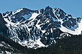 Northwest aspect
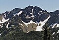 Northwest aspect
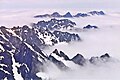 View from Mount Constance with Buckhorn, Iron, and Worthington at top


See also
- Geology of the Pacific Northwest
References
- "Iron Mountain, Washington". Peakbagger.com.
- USGS topographic map, Mount Townsend Quadrangle
- "Iron Mountain - 6,826' WA". listsofjohn.com. Retrieved 2022-02-18.
- "Iron Mountain". Geographic Names Information System. United States Geological Survey. Retrieved 2022-02-18.
- Climber's Guide to the Olympic Mountains, Olympic Mountain Rescue, Third Edition, 1988, The Mountaineers Books, page 25.
- Peel, M. C.; Finlayson, B. L.; McMahon, T. A. (2007). "Updated world map of the Köppen−Geiger climate classification". Hydrol. Earth Syst. Sci. 11. ISSN 1027-5606.
- Alt, D.D.; Hyndman, D.W. (1984). Roadside Geology of Washington. pp. 249–259. ISBN 0-87842-160-2.
External links
Places adjacent to Iron Mountain (Jefferson County, Washington) | ||||||||||||||||
|---|---|---|---|---|---|---|---|---|---|---|---|---|---|---|---|---|
| ||||||||||||||||
Другой контент может иметь иную лицензию. Перед использованием материалов сайта WikiSort.org внимательно изучите правила лицензирования конкретных элементов наполнения сайта.
WikiSort.org - проект по пересортировке и дополнению контента Википедии