geo.wikisort.org - Mountains
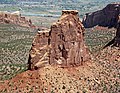
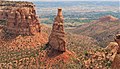
Independence Monument is a 5,739-foot-elevation (1,749 meter) sandstone pillar located in Colorado National Monument, in Mesa County of western Colorado, United States.[1] This iconic 450-foot-high landmark is situated one mile southeast of the monument's visitor center, and 9 miles (14 km) west of the community of Grand Junction, where it towers above the floor of Monument Canyon and Wedding Canyon.[5] It is a popular climbing destination, and can be seen from Rim Rock Drive.
| Independence Monument | |
|---|---|
| Independence Rock[1] | |
 South aspect | |
| Highest point | |
| Elevation | 5,739 ft (1,749 m)[2] |
| Prominence | 379 ft (116 m)[2] |
| Parent peak | The Island (5,770 ft)[3] |
| Isolation | 0.26 mi (0.42 km)[3] |
| Coordinates | 39°05′45″N 108°43′24″W[1] |
| Geography | |
 Independence Monument Location in Colorado  Independence Monument Independence Monument (the United States) | |
| Location | Colorado National Monument Mesa County, Colorado, U.S. |
| Parent range | Colorado Plateau Uncompahgre Plateau[2] |
| Topo map | USGS Colorado National Monument |
| Geology | |
| Age of rock | Late Triassic to Early Jurassic[4] |
| Type of rock | Wingate Sandstone |
| Climbing | |
| First ascent | June 14, 1911 John Otto |
| Easiest route | class 5.9- climbing[3] |
History
John Otto first arrived in the Grand Junction area in 1906. He lived alone in the canyons and used a pick and shovel to carve out trails. Otto is remembered as Colorado National Monument's founder, and its first custodian. A fervent patriot, he named the rock features after great heroes and historic events, with Independence Monument still bearing the name he bestowed.

John Otto made the first ascent of Independence Monument on June 14, 1911, flying Old Glory from the summit for Flag Day.[6][7][8] That flag was presented to Otto by President William Howard Taft.[9] Subsequently, he would make the ascent on July 4 each year to again display the flag to celebrate Independence Day. But it wasn't climbing as is commonly practiced today. His method involved drilling holes and pounding in pieces of pipe to create a ladder. The pipes Otto attached were removed in the mid-1950s by the Park Service, but handholds and steps which he carved into the sandstone remain.[10] John Otto married Boston artist Beatrice Farnham on June 20, 1911, at the base of Independence Monument in Wedding Canyon.[11]
It has become an annual tradition among climbers to raise the flag on the summit on July 4th each year.[12]
Climbing
Established rock climbing routes on Independence Monument:[13]
- Otto's Route – class 5.8+ – 5 pitches – First Ascent 1911 (by John Otto)
- Independence Chimney – class 5.8 – 6 pitches – FA 1970 (by Mike Dudley and Fletcher Smith)
- South Face Direct – class 5.9 – 5 pitches – FA 1971 (by Mike Dudley, Art Howells, Don Doucette)
- Sundial Dihedral – class 5.11b – 6 pitches – FA 1986 (by Ed Webster and Peter Athans)
- Dependence – class 5.10+ – 5 pitches – FA 1994 (by Jon Butler, Cam Burns, and Luke Laeser)
- Geezer Highway – class 5.9+ – 6 pitches (by Mike Dudley and Dennis Willis)
Geology
This monolith is the remnant of a differentially eroded fin composed primarily of cliff-forming Wingate Sandstone, which consists of wind-borne, cross-bedded quartzose sandstones deposited as ancient sand dunes approximately 200 million years ago in the Late Triassic. The thin caprock at the summit consists of fluvial sandstones of the resistant Kayenta Formation. The slope around the base of the Independence Monument is Chinle Formation.[14] The floor of the canyon is Precambrian basement rock consisting of gneiss, schist, and granites. Precipitation runoff from this geographical feature drains to the Colorado River, approximately two miles to the northeast.
Climate
According to the Köppen climate classification system, Independence Monument is located in a semi-arid climate zone.[15] Summers are hot and dry, while winters are cold with some snow. Temperatures reach 100 °F (38 °C) on 5.3 days, 90 °F (32 °C) on 57 days, and remain at or below freezing on 13 days annually. The months April through October offer the most favorable weather to visit.
| Climate data for Colorado National Monument (1981–2010 normals) | |||||||||||||
|---|---|---|---|---|---|---|---|---|---|---|---|---|---|
| Month | Jan | Feb | Mar | Apr | May | Jun | Jul | Aug | Sep | Oct | Nov | Dec | Year |
| Average high °F (°C) | 38.6 (3.7) |
44.1 (6.7) |
54.4 (12.4) |
62.9 (17.2) |
74.0 (23.3) |
85.8 (29.9) |
92.3 (33.5) |
89.1 (31.7) |
79.8 (26.6) |
65.4 (18.6) |
49.6 (9.8) |
38.7 (3.7) |
64.6 (18.1) |
| Average low °F (°C) | 22.4 (−5.3) |
26.9 (−2.8) |
34.4 (1.3) |
40.7 (4.8) |
50.3 (10.2) |
59.6 (15.3) |
65.9 (18.8) |
63.3 (17.4) |
55.0 (12.8) |
43.3 (6.3) |
31.7 (−0.2) |
23.3 (−4.8) |
43.1 (6.2) |
| Average precipitation inches (mm) | 0.74 (19) |
0.71 (18) |
1.02 (26) |
1.07 (27) |
1.05 (27) |
0.74 (19) |
0.84 (21) |
1.07 (27) |
1.22 (31) |
1.28 (33) |
0.97 (25) |
0.78 (20) |
11.51 (292) |
| Average snowfall inches (cm) | 5.8 (15) |
4.9 (12) |
3.3 (8.4) |
1.1 (2.8) |
0 (0) |
0 (0) |
0 (0) |
0 (0) |
0 (0) |
0.5 (1.3) |
2.5 (6.4) |
6.6 (17) |
24.7 (62.9) |
| Average precipitation days (≥ 0.01 in) | 5.3 | 5.3 | 6.4 | 5.7 | 5.8 | 4.1 | 6.1 | 7.0 | 6.3 | 6.2 | 5.6 | 5.7 | 69.7 |
| Average snowy days (≥ 0.1 in) | 3.9 | 2.9 | 2.3 | 0.6 | 0 | 0 | 0 | 0 | 0 | 0.4 | 1.8 | 4.2 | 16.1 |
| Source: NOAA[16] | |||||||||||||
Gallery
 Climbers nearing the summit, Note the steps John Otto carved into the rock.


 Independence Monument (left), Kissing Couple (right)
 Pipe Organ (left), Independence Monument (right) from Rim Rock Drive
 Climbers at the top of the first pitch of Otto's Route
 Left to rightː Egypt Rock, Kissing Couple, Grand View Spire, Independence Monument (centered), Pipe Organ (right).
 Aerial view with Independence Monument centered


See also
- List of rock formations in the United States
- Kissing Couple
- Pipe Organ
- Grand View Spire
References
- "Independence Monument". Geographic Names Information System. United States Geological Survey. Retrieved 2021-03-16.
- "Independence Monument, Colorado". Peakbagger.com. Retrieved 2021-03-16.
- "Independence Monument - 5,739' CO". listsofjohn.com. Retrieved 2021-03-16.
- Geologic Formations, National Park Service
- Freedom Flies High, National Park Service
- Dennis Webb, Patriotic climbers follow tradition as old as Colorado National Monument, The Daily Sentinel, July 5, 2020
- Stanley William Lohman, The Geologic Story of Colorado National Monument, Geological Survey Bulletin 1508, page 1.
- Cameron Burns, Selected Climbs in the Desert Southwest: Colorado and Utah, 1999, Mountaineers Books, ISBN 9780898866575, page 31.
- Alan J. Kania, Colorado National Monument, 2008, Arcadia Publishing, ISBN 9780738569796, page 33.
- Jeff Achey, 2002, Climb! The History of Rock Climbing in Colorado, The Mountaineers Books, page 124.
- John Otto, National Park Service
- Dennis Webb, Patriotic climbers follow tradition as old as Colorado National Monument, The Daily Sentinel, July 5, 2020
- Independence Monument Rock Climbing Mountain Project
- Stanley William Lohman, The Geologic Story of Colorado National Monument, Geological Survey Bulletin 1508, pages 18, 28-29.
- Peel, M. C.; Finlayson, B. L.; McMahon, T. A. (2007). "Updated world map of the Köppen−Geiger climate classification". Hydrol. Earth Syst. Sci. 11. ISSN 1027-5606.
- "NowData - NOAA Online Weather Data". National Oceanic and Atmospheric Administration. Retrieved 2013-07-03.
External links
- Weather forecast: National Weather Service
- Independence Monument rock climbing: Mountainproject.com
- Climbing Otto's Route video: YouTube
- Independence Day Tradition: National Park Service
На других языках
- [en] Independence Monument (Colorado)
[fr] Independence Monument
L'Independence Monument est une formation rocheuse américaine située dans le comté de Mesa, au Colorado. Culminant à 1 749 mètres d'altitude, elle est protégée au sein du Colorado National Monument.Другой контент может иметь иную лицензию. Перед использованием материалов сайта WikiSort.org внимательно изучите правила лицензирования конкретных элементов наполнения сайта.
WikiSort.org - проект по пересортировке и дополнению контента Википедии