geo.wikisort.org - Mountains
Ilfjellet is a mountain in the municipality of Rennebu in Trøndelag county, Norway. It is located in the northeastern part of the municipality, about 13 kilometres (8.1 mi) north of the municipal center of Berkåk and 10 kilometres (6.2 mi) southeast of Å in neighboring Meldal municipality. The mountain is 1,218 metres (3,996 ft) tall.[2]
| Ilfjellet | |
|---|---|
 Ilfjellet seen from Kråkfjellet (north east) | |
| Highest point | |
| Elevation | 1,218 m (3,996 ft) |
| Prominence | 790 m (2,590 ft) |
| Coordinates | 62.9456°N 09.9414°E[1] |
| Geography | |
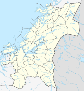 Ilfjellet Location of the mountain  Ilfjellet Ilfjellet (Norway) | |
| Location | Trøndelag, Norway |
| Topo map | 1520 I Rennebu |
Name
The mountain is named after the river Ila. The last element is the finite form of fjell which means "fell" or "mountain". The river name is derived from Old Norse íla which means "spring".
References
- "Ilfjellet, Rennebu (Trøndelag)" (in Norwegian). yr.no. Retrieved 2018-01-25.
- Store norske leksikon. "Ilfjellet" (in Norwegian). Retrieved 2011-02-02.
This Trøndelag location article is a stub. You can help Wikipedia by expanding it. |
На других языках
[de] Ilfjellet
Der Ilfjellet ist ein 1218 moh.[1] hoher Berg in Norwegen. Er liegt in der Provinz Trøndelag und gehört zur Gemeinde Rennebu. Er befindet sich im nordöstlichen Teil des Gemeindegebietes, etwa 13,2 km nördlich der Ortschaft Berkåk und 11,1 km südöstlich von Å in der Gemeinde Meldal.[2] Die Schartenhöhe des Berges beträgt 788[3] bis 790[4] m, die Dominanz gegenüber dem nächsthöheren Berg, dem Digerhøa (1254 moh.), beträgt etwa 21,3 km.[5]- [en] Ilfjellet
Текст в блоке "Читать" взят с сайта "Википедия" и доступен по лицензии Creative Commons Attribution-ShareAlike; в отдельных случаях могут действовать дополнительные условия.
Другой контент может иметь иную лицензию. Перед использованием материалов сайта WikiSort.org внимательно изучите правила лицензирования конкретных элементов наполнения сайта.
Другой контент может иметь иную лицензию. Перед использованием материалов сайта WikiSort.org внимательно изучите правила лицензирования конкретных элементов наполнения сайта.
2019-2026
WikiSort.org - проект по пересортировке и дополнению контента Википедии
WikiSort.org - проект по пересортировке и дополнению контента Википедии