geo.wikisort.org - Mountains
Hurrungane (also written Hurrungene, Hurrungadn, Horungane) is a mountain range in the municipalities Luster and Årdal in Vestland county, Norway. The area is southwest in the larger mountain range Jotunheimen and is also part of Jotunheimen National Park.[2]
| Hurrungane | |
|---|---|
| Hurrungene, Hurrungadn, Horungane | |
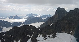
 Hurrungane seen looking towards the west. Store Skagastølstind is the highest peak visible. | |
| Highest point | |
| Peak | Store Skagastølstind, Luster/Årdal, Norway |
| Elevation | 2,405 m (7,890 ft) |
| Coordinates | 61°27′41″N 07°52′17″E |
| Geography | |
 Location of the mountain  Hurrungane (Norway) | |
| Location | Vestland, Norway |
| Range coordinates | 61.4495°N 7.8434°E[1] |
| Parent range | Jotunheimen |
The range has some of the most alpine peaks in Norway, and has 23 peaks over 2,000 metres (6,600 ft) (counting peaks with larger prominence than 30 metres or 98 feet). Several of the peaks are only accessible through climbing or glacier crossings. The starting point for hiking is the village of Turtagrø along the national tourist road, Sognefjellsvegen (RV55).
The highest peaks in the area are
- Store Skagastølstinden (Storen): 2,405 m or 7,890 ft
- Store Styggedalstinden: 2,387 m or 7,831 ft
- Jervvasstind (Gjertvasstind): 2,351 m or 7,713 ft
- Sentraltind: 2,348 m or 7,703 ft
- Vetle Skagastølstind: 2,340 m or 7,680 ft
- Midtre Skagastølstind: 2,284 m or 7,493 ft
- Skagastølsnebbet: 2,222 m or 7,290 ft
- Store Austanbotntind: 2,202 m or 7,224 ft
Name
Hurrungane is the finite plural of a word hurrung. Hurrungen, the finite singular of the same word, is the names of two mountains in Rauma and Skjåk. The first element is the verb hurra which means "hurry, move fast (with noise and roar)". The last element is the suffix -ung, referring to an active thing/person. The actual mountains are steep, and there are frequent rockslides and avalanches from the hillsides. The meaning of the name is then "the noisemakers".[3]

See also
- List of mountains of Norway
References
- "Hurrungane, Luster (Vestland)" (in Norwegian). yr.no. Retrieved 2020-01-07.
- Store norske leksikon. "Hurrungane" (in Norwegian). Retrieved 2010-09-10.
- Baxter, James (2005). Scandinavian Mountains and Peaks Over 2000 Metres in the Hurrungane. ISBN 978-0-9550497-0-5.
На других языках
[de] Hurrungane
Als Hurrungane wird eine Gebirgsgruppe im südwestlichen Jotunheimen-Gebirge bezeichnet. Das Gebiet erstreckt sich östlich der innersten Ausläufer des Sognefjordes, des Lustrafjordes und des Årdalsfjordes. Nach Norden wird es vom Sognefjell und nach Südosten vom tief eingeschnittenen Utladalen begrenzt. Hurrungane liegt auf den Gemarkungen der Gemeinden Luster und Årdal und ist Teil des Jotunheimen-Nationalparks. Im Süden von Hurrungane liegt die Ortschaft Øvre Årdal. Die Straße von Øvre Årdal nach Turtagrø im Norden ist die einzige Verkehrsanbindung.- [en] Hurrungane
[fr] Hurrungane
Le Hurrungane est un massif de montagne situé en Norvège. Il compte 23 pics de plus de 2 000 mètres.[it] Hurrungane
Lo Hurrungane (scritto anche come Hurrungene, Hurrungadn, Horungane) è un massiccio montuoso appartenente alla catena dello Jotunheimen, nelle Alpi scandinave, situato nella contea di Vestland, in Norvegia.Другой контент может иметь иную лицензию. Перед использованием материалов сайта WikiSort.org внимательно изучите правила лицензирования конкретных элементов наполнения сайта.
WikiSort.org - проект по пересортировке и дополнению контента Википедии