geo.wikisort.org - Mountains
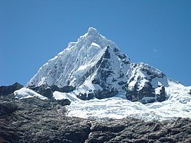
Huaguruncho,[1][2][3][4][5] Tarata[6][7] or Huagaruncho[4][8] is a 5,723-metre-high (18,776 ft)[3][4][7] mountain in the Huaguruncho mountain range in the Andes of Peru. Its highest peak, officially named Tarata,[7] is located in the Pasco Region, Pasco Province, on the border of the districts of Huachón and Ticlacayan. A minor peak, named Huaguruncho Chico[7] by the IGN map, lies west of it in the Ticlacayan District.[6]
| Huaguruncho | |
|---|---|
| Tarata | |
 | |
| Highest point | |
| Elevation | 5,723 m (18,776 ft) |
| Coordinates | 10°31′52″S 75°55′54″W |
| Geography | |
 Huaguruncho Peru | |
| Location | Peru, Pasco Region |
| Parent range | Andes, Waqurunchu |
Research revealed that fluctuations in Huaguruncho's glaciers were caused by temperature changes in the tropical Atlantic Ocean, with the last major glacial expansion occurring ca. 4000–2000 years ago.[5]
References
- Lezameta, Pablo (2004). Documental de la provincia de Pachitea. Ediciones PASALEAP. pp. 12, 15, 20.
- Box, Ben (1999). The South American Handbook. McGraw-Hill/Contemporary. p. 1380. ISBN 9780844249841.
- "Huaguruncho". www.montanasperuanas.com. Archived from the original on 2016-08-20. Retrieved 2016-07-16.
- Biggar, John (2005). The Andes: A Guide for Climbers. Andes. p. 107. ISBN 9780953608720.
Huagaruncho
- Stansell, Nathan D.; et al. (2015). "Late Glacial and Holocene glacier fluctuations at Nevado Huaguruncho in the Eastern Cordillera of the Peruvian Andes". Geology. 43 (8): 747–750. doi:10.1130/G36735.1.
- escale.minedu.gob.pe - UGEL map of the Pasco Province (Pasco Region)
- Peru 1:100 000, Ulcumayo (22-l). IGN (Instituto Geográfico Nacional - Perú).
- Neate, Jill (1994). "Peru". Mountaineering in the Andes. RGS-IBG Expedition Advisory Centre. ISBN 0-907649-64-5.
Huagaruncho
На других языках
[de] Huaguruncho
Der Huaguruncho oder Nevado Huaguruncho (auch Nevado Tarata oder Nevado Huagaruncho) ist ein vergletscherter Berg in der Verwaltungsregion Pasco in Zentral-Peru. Der Berg liegt in der Provinz Pasco. Die Distrikte Huachón und Ticlacayán treffen hier aufeinander. Der Huaguruncho ist mit 5723 m die höchste Erhebung der Cordillera Huaguruncho, einem Gebirgszug der peruanischen Zentralkordillere. Am Südfuß des Berges liegt die Ortschaft Huachón.- [en] Huaguruncho
Текст в блоке "Читать" взят с сайта "Википедия" и доступен по лицензии Creative Commons Attribution-ShareAlike; в отдельных случаях могут действовать дополнительные условия.
Другой контент может иметь иную лицензию. Перед использованием материалов сайта WikiSort.org внимательно изучите правила лицензирования конкретных элементов наполнения сайта.
Другой контент может иметь иную лицензию. Перед использованием материалов сайта WikiSort.org внимательно изучите правила лицензирования конкретных элементов наполнения сайта.
2019-2025
WikiSort.org - проект по пересортировке и дополнению контента Википедии
WikiSort.org - проект по пересортировке и дополнению контента Википедии