geo.wikisort.org - Mountains
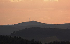
At 674.9 metres (2,214 ft)[1] the Hochkelberg is one of the ten highest mountains in the Vulkan Eifel in Germany. It is a former stratovolcano, at the southern foot of which lies the Mosbrucher Weiher, an explosion crater lake or maar. Below the summit of the Hochkelberg is a transmission tower.
| Hochkelberg | |
|---|---|
 The summit of the Hochkelberg seen from Gänsehals | |
| Highest point | |
| Elevation | 674.9 m (2,214 ft)[1] |
| Coordinates | 50°16′22″N 6°57′10″E |
| Geography | |
 Hochkelberg Rheinland-Pfalz, Germany | |
| Parent range | Eifel |
Originally the mountain which is visible today lay 200 metres below the surface. When the region was uplifted the outer layers were carried away leaving the hard basaltic core.
The slopes of the Hochkelberg are covered today with dense beech woods with a variety of species. The ruins of Roman buildings may also be seen here.
References
На других языках
[de] Hochkelberg
Der Hochkelberg im Landkreis Vulkaneifel (Rheinland-Pfalz) ist mit 674,9 m ü. NHN[1] Höhe der dritthöchste Berg der Hocheifel und ein ehemaliger Schichtvulkan.- [en] Hochkelberg
Текст в блоке "Читать" взят с сайта "Википедия" и доступен по лицензии Creative Commons Attribution-ShareAlike; в отдельных случаях могут действовать дополнительные условия.
Другой контент может иметь иную лицензию. Перед использованием материалов сайта WikiSort.org внимательно изучите правила лицензирования конкретных элементов наполнения сайта.
Другой контент может иметь иную лицензию. Перед использованием материалов сайта WikiSort.org внимательно изучите правила лицензирования конкретных элементов наполнения сайта.
2019-2025
WikiSort.org - проект по пересортировке и дополнению контента Википедии
WikiSort.org - проект по пересортировке и дополнению контента Википедии