geo.wikisort.org - Mountains
Hidden Lake Peaks[2] is series of peaks with a maximum elevation of 7,088 feet (2,160 meters) that are located in the North Cascades, in Skagit County of Washington state. The peaks extend three miles southwest from the nearest higher peak called The Triad.[1] Situated on the western boundary of North Cascades National Park, Hidden Lake Peaks are positioned west of the crest of the Cascade Range, approximately ten miles east of the town of Marblemount. The popular subsidiary peak, Hidden Lake Lookout (6890 ft), lies a half mile to the southwest of the highest summit.[3] The mountain's name is taken from its proximity to Hidden Lake which lies in a cirque below the east aspect of these two main peaks. Precipitation runoff from Hidden Lake Peaks drains into Cascade River which is a tributary of the Skagit River.
| Hidden Lake Peaks | |
|---|---|
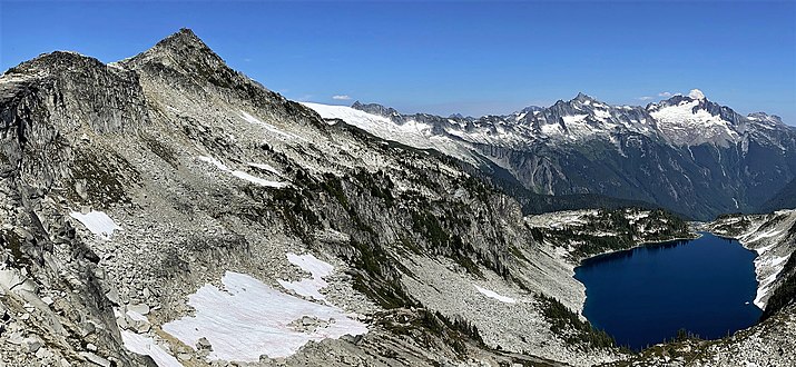
 Hidden Lake Peaks from the east near Cascade Pass | |
| Highest point | |
| Elevation | 7,088 ft (2,160 m)[1] |
| Prominence | 1,008 ft (307 m)[1] |
| Coordinates | 48°30′03″N 121°11′51″W[1] |
| Geography | |
 Hidden Lake Peaks Location in Washington  Hidden Lake Peaks Location in the United States | |
| Location | Skagit County, Washington, U.S. |
| Parent range | North Cascades |
| Topo map | USGS Eldorado Peak |
| Geology | |
| Type of rock | Granite |
| Climbing | |
| Easiest route | Hiking trail to lookout Scrambling class 2 to summit |
Climate
Hidden Lake Peaks are located in the marine west coast climate zone of western North America.[4] Most weather fronts originate in the Pacific Ocean, and travel northeast toward the Cascade Mountains. As fronts approach the North Cascades, they are forced upward by the peaks of the Cascade Range (Orographic lift), causing them to drop their moisture in the form of rain or snowfall onto the Cascades. As a result, the west side of the North Cascades experiences high precipitation, especially during the winter months in the form of snowfall. During winter months, weather is usually cloudy, but, due to high pressure systems over the Pacific Ocean that intensify during summer months, there is often little or no cloud cover during the summer.[4] Because of maritime influence, snow tends to be wet and heavy, resulting in high avalanche danger, particularly on the steep western meadow-covered slopes that are above treeline.[4]
Geology
The North Cascades features some of the most rugged topography in the Cascade Range with craggy peaks and ridges, deep glacial valleys, and granite spires.

Geological events occurring many years ago created the diverse topography and drastic elevation changes over the Cascade Range leading to various climate differences.
The history of the formation of the Cascade Mountains dates back millions of years ago to the late Eocene Epoch.[5] With the North American Plate overriding the Pacific Plate, episodes of volcanic igneous activity persisted.[5] In addition, small fragments of the oceanic and continental lithosphere called terranes created the North Cascades about 50 million years ago.[5]
During the Pleistocene period dating back over two million years ago, glaciation advancing and retreating repeatedly scoured the landscape leaving deposits of rock debris.[5] The “U”-shaped cross section of the river valleys are a result of recent glaciation. Uplift and faulting in combination with glaciation have been the dominant processes which have created the tall peaks and deep valleys of the North Cascades area.
Hidden Lake Peak Lookout
The gable roof single-room 14' by 14' lookout was built by the U.S. Forest Service in 1931 and was staffed until 1958, when many fire lookouts in the North Cascades were closed. In 1961 Dr. Fred Darvill and the Skagit Alpine Club obtained a special use permit to restore and maintain the structure. A volunteer group now maintains the lookout, which is open to the public on a first-come-first-serve basis for overnight use. The lookout is generally accessible from July until October, as determined by snow conditions.
National Register
The Hidden Lake Peak Lookout was added to the National Register of Historic Places on July 14, 1987,[6] and is also on the National Historic Lookout Register.[7]

- Structure - ID #87001184
- North Cascades National Park overlooking the Cascade Pass area
- Historic Significance: Event, Architecture/Engineering
- Area of Significance: Architecture, Conservation, Politics/Government
- Period of Significance: 1931-1958
- Owner: Federal
- Historic Function: Government
- Historic Sub-function: Fire Station
- Current Function: Government
- Current Sub-function: Fire Station
- North Cascades National Park 10 miles (16 km) east of Marblemount, Washington
- Elevation 6,890 feet (2,100 m)
Access
The trailhead for Hidden Lake Trail #745 to the top of Hidden Lake Peak Lookout is located at the end of five mile long Forest Service Road #1540, which junctions 9.5 miles up the Cascade River Road from Marblemount. The steep 4.5 miles (7.2 km) trail, with a 2,900-foot (880 m) elevation gain, starts in forest then transitions to wonderful wildflower filled meadows before climbing high into heather and rock gardens.[8] The summit provides views of the peaks of the Ptarmigan Traverse, the stratovolcanoes Glacier Peak and Mount Baker, and other giants such as Forbidden Peak, Eldorado Peak, and Snowking Mountain.
Gallery
 Hidden Lake Peak and Hidden Lake
 One of the northern Hidden Lake Peaks
 The highest of the Hidden Lake Peaks seen from the lookout with Dorado Needle (left) and Eldorado Peak (right)
 Hidden Lake Peaks with Early Morning Spire and Dorado Needle (left)
 Snowking Mountain seen from Hidden Lake Peak
 Hidden Lake Peaks, east aspect
 Mt. Baker seen from Hidden Lake Peaks


See also
- Geography of the North Cascades
- Geology of the Pacific Northwest
References
- "Hidden Lake Peaks, Washington". Peakbagger.com.
- "Hidden Lake Peaks". Geographic Names Information System. United States Geological Survey. Retrieved 2019-05-11.
- "Hidden Lake Lookout, Washington". Peakbagger.com.
- Beckey, Fred W. Cascade Alpine Guide, Climbing and High Routes. Seattle, WA: Mountaineers Books, 2008.
- Kruckeberg, Arthur (1991). The Natural History of Puget Sound Country. University of Washington Press.
- Skagit County listings at National Register of Historic Places
- "Hidden Lake Peak Lookout | National Historic Lookout Register".
- "Hidden Lake Lookout Trail #745 Mt. Baker-Snoqualmie National Forest". U.S. Forest Service. Retrieved 2019-05-11.
External links
- Hidden Lake Trail National Park Service
- Hidden Lake Peaks weather: Mountain Forecast
- Hidden Lake Peaks: YouTube
- Hidden Lake Peaks photo: Flickr
Places adjacent to Hidden Lake Peaks | ||||||||||||||||
|---|---|---|---|---|---|---|---|---|---|---|---|---|---|---|---|---|
| ||||||||||||||||
Другой контент может иметь иную лицензию. Перед использованием материалов сайта WikiSort.org внимательно изучите правила лицензирования конкретных элементов наполнения сайта.
WikiSort.org - проект по пересортировке и дополнению контента Википедии