geo.wikisort.org - Mountains
The Hasenhorn is a mountain, 1,155.6 m above sea level (NHN)[1], in the Southern Black Forest in Germany. The mountain lies southeast of the little town of Todtnau.
| Hasenhorn | |
|---|---|
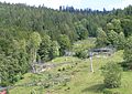
 Hasenhorn - view from the refuge hut above the church of St. John the Baptist | |
| Highest point | |
| Elevation | 1,156 m (3,793 ft) |
| Coordinates | 47°49′16.6″N 07°57′6.54″E |
| Geography | |
 Hasenhorn Baden-Württemberg, Germany | |
| Parent range | Southern Black Forest |
In 2004, the old single chairlift on the Hasenhorn was removed and replaced by modern double chairlift. At the same time, an all-weather toboggan run (Rodelbahn) was built on the Hasenhorn, at the time the longest of its kind in Germany. The run is owned by an investor who also owns the Steinwasen Park. In addition, on the Hasenhorn there are suitable downhill runs and, in winter, a prepared toboggan run. In the vicinity of the chairlift's top station is a restaurant, the Berggasthaus Hasenhorn.
 The all-weather toboggan run
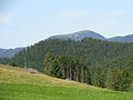 The Hasenhorn and its tower (seen from the Gisibodenalm)
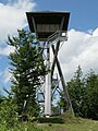 The Hasenhorn Tower


References
- Map services of the Federal Agency for Nature Conservation
External links
- Badische Seiten: Hasenhorn
- Todtnauer Ferienland: Ausflugsziele
- Hasenhorn Coasterbahn
- Lift databank Hasenhorn
- Description of the Hasenhorns at Badische Seiten.de
На других языках
[de] Hasenhorn
Das Hasenhorn ist ein 1155,8 m ü. NHN[1] hoher Berg im Schwarzwald. Er liegt bei Todtnau im baden-württembergischen Landkreis Lörrach.- [en] Hasenhorn
Текст в блоке "Читать" взят с сайта "Википедия" и доступен по лицензии Creative Commons Attribution-ShareAlike; в отдельных случаях могут действовать дополнительные условия.
Другой контент может иметь иную лицензию. Перед использованием материалов сайта WikiSort.org внимательно изучите правила лицензирования конкретных элементов наполнения сайта.
Другой контент может иметь иную лицензию. Перед использованием материалов сайта WikiSort.org внимательно изучите правила лицензирования конкретных элементов наполнения сайта.
2019-2026
WikiSort.org - проект по пересортировке и дополнению контента Википедии
WikiSort.org - проект по пересортировке и дополнению контента Википедии