geo.wikisort.org - Mountains
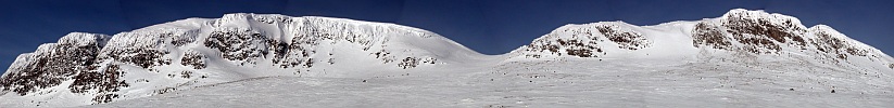
Hallingskarvet is a mountain range in southern Norway stretching from Geilo to Finse in Vestland and Viken counties. The highest point is the 1,933-metre (6,342 ft) tall mountain Folarskardnuten in Hol Municipality in Viken county.
| Hallingskarvet | |
|---|---|
 | |
| Highest point | |
| Peak | Folarskardnuten, Hol, Viken |
| Elevation | 1,933 m (6,342 ft) |
| Coordinates | 60.6128°N 7.7861°E |
| Dimensions | |
| Length | 35 km (22 mi) |
| Geography | |
 Location of the mountain  Hallingskarvet (Viken (county))  Hallingskarvet (Norway) | |
| Location | Vestland and Viken, Norway |
| Range coordinates | 60.6128°N 7.6662°E[1] |
In the north, there is a large dammed lake called Strandavatnet. The Bergen Line railway, which runs south of Hallingskarvet, has its highest stop at Finse Station at an elevation of 1,222 metres (4,009 ft).[2]
In 2006, the Hallingskarvet mountain range became part of the Hallingskarvet National Park.
See also
- List of mountains of Norway
References
- "Hallingskarvet, Hol (Viken)" (in Norwegian). yr.no. Retrieved 2020-03-01.
- Store norske leksikon. "Hallingskarvet" (in Norwegian). Retrieved 2014-05-25.
| Authority control |
|
|---|
This article about a mountain, mountain range, or peak in Vestland is a stub. You can help Wikipedia by expanding it. |
This article about a mountain, mountain range, or peak in Viken is a stub. You can help Wikipedia by expanding it. |
На других языках
[de] Hallingskarvet
Das Hallingskarvet ist ein etwa 35 km[1] langer Gebirgskamm in Südnorwegen. Der Gebirgskamm liegt östlich des Hardangerjøkulen-Gletschers und nördlich der Hardangervidda-Hochebene, in etwa zwischen den Orten Geilo und Finse.[1] Der höchste Punkt ist der Folarskardnuten mit 1933 moh., welcher auch den höchsten Punkt in der ehemaligen Provinz Buskerud darstellt. Im oberen Bereich gestaltet sich das Massiv plateauartig.[1]- [en] Hallingskarvet
[fr] Hallingskarvet
Hallingskarvet est une arête montagneuse longue de 35 km située dans le comté de Viken en Norvège. Le point culminant du massif est Folarskardnuten à 1 933 m d'altitude. Le massif est inclus dans le parc national de Hallingskarvet.Другой контент может иметь иную лицензию. Перед использованием материалов сайта WikiSort.org внимательно изучите правила лицензирования конкретных элементов наполнения сайта.
WikiSort.org - проект по пересортировке и дополнению контента Википедии