geo.wikisort.org - Mountains
Hal Foss Peak is a 7,179-foot-elevation (2,188 m) mountain summit located in the Olympic Mountains, in Jefferson County of Washington state.[4] It is situated within Olympic National Park, and the Daniel J. Evans Wilderness. The nearest higher neighbor is Mount Mystery, 0.6 miles (0.97 km) to the southwest, and Mount Fricaba is 0.74 miles (1.19 km) to the northeast.[5] Precipitation runoff from the peak drains east to the Dungeness River via Heather Creek, and west into Deception Creek which is a tributary of the Dosewallips River. Topographic relief is significant as the summit rises 2,800 feet (853 m) above Heather Creek in approximately one mile.
| Hal Foss Peak | |
|---|---|
 South aspect | |
| Highest point | |
| Elevation | 7,179 ft (2,188 m)[1] |
| Prominence | 419 ft (128 m)[2] |
| Parent peak | Mount Mystery (7,639 ft)[3] |
| Isolation | 0.60 mi (0.97 km)[3] |
| Coordinates | 47°47′58″N 123°12′34″W[4] |
| Naming | |
| Etymology | Harold Alfred "Hal" Foss |
| Geography | |
 Hal Foss Peak Location in Washington  Hal Foss Peak Hal Foss Peak (the United States) | |
| Location | Olympic National Park Jefferson County, Washington, U.S. |
| Parent range | Olympic Mountains |
| Topo map | USGS Mount Deception |
| Climbing | |
| Easiest route | class 2 scrambling via Mt. Fricaba[2] |
Etymology
The mountain's name was officially adopted in 1977 by the United States Board on Geographic Names to honor Harold Alfred "Hal" Foss (1922–1974), the first Search and Rescue coordinator for the Washington State Department of Emergency Services.[4][1] He was instrumental in forming the National Search and Rescue Coordinators Association, of which he was president.[6] He was also president of the Mountain Rescue Association, chairman of the Washington Mountain Rescue Council, and member of the American Alpine Club.[7] Foss died of a heart attack while climbing Mount St. Helens with his 18-year-old son Lynn on July 14, 1974.[8]
Climate
Hal Foss Peak is located in the marine west coast climate zone of western North America.[9] Most weather fronts originate in the Pacific Ocean, and travel east toward the Olympic Mountains. As fronts approach, they are forced upward by the peaks of the Olympic Range, causing them to drop their moisture in the form of rain or snowfall (Orographic lift). As a result, the Olympics experience high precipitation, especially during the winter months in the form of snowfall.[9] During winter months, weather is usually cloudy, but due to high pressure systems over the Pacific Ocean that intensify during summer months, there is often little or no cloud cover during the summer. The months July through September offer the most favorable weather for climbing Hal Foss Peak.[2]
Gallery
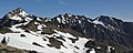 Mount Mystery (left), Hal Foss Peak (center), and Mount Fricaba (right).
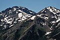 Hal Foss Peak to left with Mount Mystery looming directly behind it.
Mount Fricaba to right. View from Marmot Pass. The two prominent peaks in the distance are Mts. Mystery and Deception.
Hal Foss Peak can be seen between them. View is from Mt. Constance.


See also
- Olympic Mountains
- Geology of the Pacific Northwest
References
- Olympic Mountain Rescue, Olympic Mountains: A Climbing Guide, 4th Edition, 2006, Mountaineers Books, ISBN 9780898862065, page 146.
- Hal Foss Peak, climbersguideolympics.com
- "Hal Foss Peak - 7,179' WA". listsofjohn.com. Retrieved 2022-01-31.
- "Hal Foss Peak". Geographic Names Information System. United States Geological Survey, United States Department of the Interior. Retrieved 2022-01-31.
- "Hal Foss Peak, Washington". Peakbagger.com.
- Decisions on Geographic Names in the United States, Decision List 7703, (1977), Department of the Interior, page 20.
- The American Alpine Journal, page 314.
- Appalachia, Volume 40, (1974), page 130.
- McNulty, Tim (2009). Olympic National Park: A Natural History. Seattle, Washington: University of Washington Press.
External links
- "Olympic National Park". National Park Service.
- Weather: Hal Foss Peak
- Tribute to Hal Foss: Search and Rescue Magazine
- Hal Foss Peak photo: Flickr
Другой контент может иметь иную лицензию. Перед использованием материалов сайта WikiSort.org внимательно изучите правила лицензирования конкретных элементов наполнения сайта.
WikiSort.org - проект по пересортировке и дополнению контента Википедии