geo.wikisort.org - Mountains
Gučevo (Serbian Cyrillic: Гучево, pronounced [ɡûːtʃeʋo]) is a mountain in western Serbia, near the town of Loznica, overlooking the Drina river and Banja Koviljača. Its highest peak Crni vrh has an elevation of 779 meters above sea level.
| Gučevo | |
|---|---|
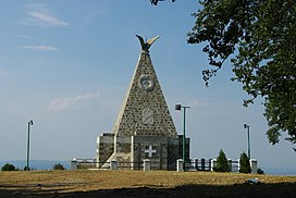
 Monument on Crni vrh | |
| Highest point | |
| Elevation | 779 m (2,556 ft)[1] |
| Coordinates | 44°28′50″N 19°11′04″E |
| Geography | |
 Gučevo Location in Serbia | |
| Location | Western Serbia |
The mountain was a site of Battle of Gučevo between Serbian and Austro-Hungarian army in World War I. At the top of the mountain there is a monument to Serbian and Austro-Hungarian soldiers.[2]
References
- Jovan Đokić. "Katalog planina Srbije". PSD Kopaonik Beograd. Archived from the original on 2011-05-18.
- Gučevo, Banja Koviljača.org, archived from the original on 2010-08-08
External links
На других языках
[de] Gučevo
Der Gučevo ist ein 779 Meter hoher Berg auf dem Gemeindegebiet von Loznica im Bezirk Mačva in Serbien.- [en] Gučevo
[fr] Gučevo (montagne)
Le mont Gučevo (en serbe cyrillique : Гучево) est une montagne de l'ouest de la Serbie. Il s'élève à une altitude de 779 m. Il est situé dans les Alpes dinariques.Текст в блоке "Читать" взят с сайта "Википедия" и доступен по лицензии Creative Commons Attribution-ShareAlike; в отдельных случаях могут действовать дополнительные условия.
Другой контент может иметь иную лицензию. Перед использованием материалов сайта WikiSort.org внимательно изучите правила лицензирования конкретных элементов наполнения сайта.
Другой контент может иметь иную лицензию. Перед использованием материалов сайта WikiSort.org внимательно изучите правила лицензирования конкретных элементов наполнения сайта.
2019-2025
WikiSort.org - проект по пересортировке и дополнению контента Википедии
WikiSort.org - проект по пересортировке и дополнению контента Википедии