geo.wikisort.org - Mountains
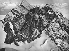
The Gspaltenhorn is a mountain of the Bernese Alps, located between the valleys of Kiental and Lauterbrunnen in the canton of Bern. With an elevation of 3,436 metres above sea level, the Gspaltenhorn is the highest summit of the range lying north-east of the Gamchilück pass (2,837 m).

| Gspaltenhorn | |
|---|---|
 The Tschingelspitz (left) and the Gspaltenhorn (right) from the Bütlasse | |
| Highest point | |
| Elevation | 3,436 m (11,273 ft) |
| Prominence | 599 m (1,965 ft)[1] |
| Parent peak | Blüemlisalp |
| Isolation | 2.7 km (1.7 mi) |
| Listing | Alpine mountains above 3000 m |
| Coordinates | 46°30′41″N 7°49′40″E |
| Geography | |
| Location | Bern, Switzerland |
| Parent range | Bernese Alps |
References
- Swisstopo maps
External links
Wikimedia Commons has media related to Gspaltenhorn.
На других языках
[de] Gspaltenhorn
Das 3436,1 m hohe Gspaltenhorn ist ein Berg der Berner Alpen in der Schweiz.- [en] Gspaltenhorn
[fr] Gspaltenhorn
Le Gspaltenhorn est un sommet des Alpes bernoises en Suisse. Il culmine à 3 436 mètres d'altitude.Текст в блоке "Читать" взят с сайта "Википедия" и доступен по лицензии Creative Commons Attribution-ShareAlike; в отдельных случаях могут действовать дополнительные условия.
Другой контент может иметь иную лицензию. Перед использованием материалов сайта WikiSort.org внимательно изучите правила лицензирования конкретных элементов наполнения сайта.
Другой контент может иметь иную лицензию. Перед использованием материалов сайта WikiSort.org внимательно изучите правила лицензирования конкретных элементов наполнения сайта.
2019-2025
WikiSort.org - проект по пересортировке и дополнению контента Википедии
WikiSort.org - проект по пересортировке и дополнению контента Википедии
