geo.wikisort.org - Mountains
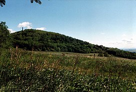
The Geisingberg is a striking basalt mountain in the eastern Ore Mountains in the German federal state of Saxony.
| Geisingberg | |
|---|---|
 | |
| Highest point | |
| Elevation | 824 m (2,703 ft) |
| Prominence | 110 m → Brautstock |
| Isolation | 1.8 km → Raubennest |
| Coordinates | 50°46′19″N 13°46′24″E |
| Geography | |
| Parent range | Ore Mountains |
| Geology | |
| Mountain type | cone |
| Type of rock | basalt |
| Climbing | |
| Access | Tower inaugurated in 1891 |
Location and surrounding area
The Geisingberg lies in the upper Eastern Ore Mountains between the mining town of Altenberg and the village of Geising. On its northern and western slopes runs the track of the Müglitz Valley Railway. With a maximum incline here of 1:27 (37 per mil) it is one of the steepest working railway lines in Germany.
Walking routes to the summit
- The easiest ascent runs from Altenberg along the road to the summit.
- Other walks being in Geising and Bärenstein.
- The Eisenach–Budapest international mountain path runs over the Geisingberg.
See also
- List of mountains in the Ore Mountains
- The Gaising (Latvian: Gaiziņkalns), the highest point in Latvia.
References
External links
| Wikimedia Commons has media related to Geisingberg. |
- Information about the Geisingberg Nature Reserve
- Homepage of the Bergbaude Geisingberg (with information about its history and geology)
На других языках
[de] Geisingberg
Der Geisingberg ist ein markanter 820,6 m ü. NHN hoher Basaltberg im östlichen Erzgebirge in der Nähe der Stadt Altenberg im Freistaat Sachsen. Zu Beginn des professionellen Wintersports war er Austragungsort mehrerer Wettkämpfe.- [en] Geisingberg
Текст в блоке "Читать" взят с сайта "Википедия" и доступен по лицензии Creative Commons Attribution-ShareAlike; в отдельных случаях могут действовать дополнительные условия.
Другой контент может иметь иную лицензию. Перед использованием материалов сайта WikiSort.org внимательно изучите правила лицензирования конкретных элементов наполнения сайта.
Другой контент может иметь иную лицензию. Перед использованием материалов сайта WikiSort.org внимательно изучите правила лицензирования конкретных элементов наполнения сайта.
2019-2025
WikiSort.org - проект по пересортировке и дополнению контента Википедии
WikiSort.org - проект по пересортировке и дополнению контента Википедии
