geo.wikisort.org - Mountains
Gaylor Peak is an 11,004-foot-elevation (3,354 meter) mountain summit located on the crest of the Sierra Nevada mountain range in northern California, United States.[5] The peak is situated on the common boundary shared by Yosemite National Park with Inyo National Forest, as well as the border shared by Mono County with Tuolumne County. It rises immediately above the park's Tioga Pass entrance station and Tioga Lake. Topographic relief is significant as the summit rises approximately 1,400 feet (427 meters) above the lake in one-half mile (1 km). The peak is a popular hiking destination on summer weekends due to easy access via the two-mile Gaylor Lakes Trail from State Route 120 which traverses the east base of the peak.[7]
| Gaylor Peak | |
|---|---|
 North aspect, from Upper Gaylor Lake | |
| Highest point | |
| Elevation | 11,004 ft (3,354 m)[1] |
| Prominence | 484 ft (148 m)[2] |
| Parent peak | False White Mountain (12,002 ft)[3] |
| Isolation | 1.95 mi (3.14 km)[3] |
| Listing | Vagmarken Club Sierra Crest List[4] |
| Coordinates | 37°55′09″N 119°15′56″W[5] |
| Naming | |
| Etymology | Andrew Jack Gaylor |
| Geography | |
 Gaylor Peak Location in California  Gaylor Peak Gaylor Peak (the United States) | |
| Location | Yosemite National Park Tuolumne / Mono counties California, United States |
| Parent range | Sierra Nevada |
| Topo map | USGS Tioga Pass |
| Geology | |
| Mountain type | Fault block |
| Type of rock | Metamorphic rock[6] |
| Climbing | |
| Easiest route | class 2[3] |
History

This mountain's toponym was officially adopted by the United States Board on Geographic Names to honor Andrew Jack Gaylor (1846–1921), one of Yosemite's first park rangers.[5] He died of a heart attack on April 19, 1921, while on patrol in the park, having worked 14 years for the National Park Service.[8] Before this landform's name was adopted, early prospectors called the peak "Tioga Hill."[9] The Great Sierra Mine Historic Site is located one-half mile north of the peak.
Climate
Gaylor Peak is located in an alpine climate zone.[10] Most weather fronts originate in the Pacific Ocean, and travel east toward the Sierra Nevada mountains. As fronts approach, they are forced upward by the peaks (orographic lift), causing moisture in the form of rain or snowfall to drop onto the range. Precipitation runoff from this mountain drains west into Gaylor Lakes thence Dana Fork Tuolumne River, and east to Tioga Lake thence Lee Vining Creek and ultimately Mono Lake.
Gallery
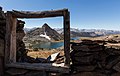 Gaylor Peak framed, from Great Sierra Mine Historic Site
 Looking northwest at Gaylor Peak (reddish top) with parent False White Mountain behind. Yosemite's Tioga Pass Entrance Station is visible on the road.
 Mount Dana (left), Kuna Crest (centered in the distance), and Gaylor Peak (right) seen from Tioga Lake.
 Summit panorama
 Gaylor Peak seen from Mount Dana
 Andrew "Jack" Gaylor, circa 1881


See also
References
- R. J. Secor, The High Sierra Peaks, Passes, Trails, 2009, Third Edition, Mountaineers Books, ISBN 9781594857386.
- "Gaylor Peak, California". Peakbagger.com. Retrieved 2022-05-08.
- "Gaylor Peak - 11,004' CA". listsofjohn.com. Retrieved 2022-05-08.
- "Vagmarken Sierra Crest List". Angeles Chapter, Sierra Club. Retrieved 2022-05-07.
- "Gaylor Peak". Geographic Names Information System. United States Geological Survey. Retrieved 2022-05-08.
- Marc J. Soares (2003), 100 Hikes in Yosemite National Park, Mountaineers Books, ISBN 9780898868678, p.170
- Marc J. Soares (2003), 100 Hikes in Yosemite National Park, Mountaineers Books, ISBN 9780898868678, p. 170
- Park Ranger Andrew Jack Gaylor, odmp.org
- Matt Johanson, Sierra Summits: A Guide to Fifty Peak Experiences in California's Range of Light, 2019, Falcon Guides, ISBN 9781493036455, page 106.
- "Climate of the Sierra Nevada". Encyclopædia Britannica.
External links
- Weather forecast: Gaylor Peak
- Yosemite's First Rangers (photo): Flickr
- Jack Gaylor: obituary
Places adjacent to Gaylor Peak | ||||||||||||||||
|---|---|---|---|---|---|---|---|---|---|---|---|---|---|---|---|---|
| ||||||||||||||||
Другой контент может иметь иную лицензию. Перед использованием материалов сайта WikiSort.org внимательно изучите правила лицензирования конкретных элементов наполнения сайта.
WikiSort.org - проект по пересортировке и дополнению контента Википедии