geo.wikisort.org - Mountains
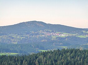
The 880-metre-high Fürberg is one of the smaller mountains in the Danube Hills, the lower part of the Bavarian Forest. It rises in the municipality of Kirchberg im Wald.
This article does not cite any sources. (May 2019) |
| Fürberg | |
|---|---|
 The Fürberg and the village of Untermitterdorf seen from the Oberkreuzberg viewing tower | |
| Highest point | |
| Elevation | 880 m (2,890 ft) |
| Coordinates | 48°52′14″N 13°12′45″E |
| Geography | |
| Parent range | Bavarian Forest |
| Geology | |
| Type of rock | granite |
At the summit is the Plattenstein, an interesting rock formation with a summit cross and view southwards to the higher Brotjacklriegel. A little further below is the Fürberg Chapel, which can be reached by walking along a way of the cross from Untermitterdorf. The Fürberg can be climbed on various footpaths in a short time from the small villages of Raindorf, Untermitterdorf or Berneck.
На других языках
[de] Fürberg (Bayerischer Wald)
Der Fürberg ist ein 880 m ü. NHN hoher Berg im vorderen Bayerischen Wald in der Gemeinde Kirchberg im Wald.- [en] Fürberg (Bavarian Forest)
Текст в блоке "Читать" взят с сайта "Википедия" и доступен по лицензии Creative Commons Attribution-ShareAlike; в отдельных случаях могут действовать дополнительные условия.
Другой контент может иметь иную лицензию. Перед использованием материалов сайта WikiSort.org внимательно изучите правила лицензирования конкретных элементов наполнения сайта.
Другой контент может иметь иную лицензию. Перед использованием материалов сайта WikiSort.org внимательно изучите правила лицензирования конкретных элементов наполнения сайта.
2019-2025
WikiSort.org - проект по пересортировке и дополнению контента Википедии
WikiSort.org - проект по пересортировке и дополнению контента Википедии
