geo.wikisort.org - Mountains
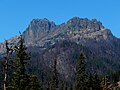
Fifes Peaks[2] is a compact group of summits and spires from an eroded volcanic cone located in Yakima County in Washington state. Fifes Peaks is situated in the Cascade Range on the east side of the crest, within the Norse Peak Wilderness. The Fifes Peaks are remnants of a now extinct caldera which exploded 25 million years ago.[3]
| Fifes Peaks | |
|---|---|
 Fifes Peaks - Central Peak seen from Mather Memorial Highway | |
| Highest point | |
| Elevation | 6,880 ft (2,100 m)[1] |
| Prominence | 440 ft (130 m)[1] |
| Coordinates | 46°58′28″N 121°19′44″W |
| Geography | |
 Fifes Peaks Location of Fifes Peaks in Washington  Fifes Peaks Fifes Peaks (the United States) | |
| Location | Yakima County, Washington, U.S. |
| Parent range | Cascades |
| Topo map | USGS Goose Prairie |
| Geology | |
| Type of rock | Andesite lava |
| Climbing | |
| Easiest route | Scrambling class 2 |
Principal summits
- Fifes Peaks West Peak - 6,880+ ft[1]
- Fifes Peaks Central Peak- 6,793 ft[1]
- Fifes Peaks East Peak - 6,375 ft[1]
- Mainmast - 6,400+ ft[4]
- Cannonhole Pinnacle - 6,600+ ft[5]
- Teddy Bear Pinnacle - 6260 ft[6]
History
Fifes Peaks were named for Thomas X. Fife (1853-1922), a placer miner.[6] Thomas, his brothers, and their father John, mined in the area near Chinook Pass. Tom homesteaded at Goose Prairie, near Bumping Lake. Camp Fife, the Boy Scout Camp at Goose Prairie, also honors Tom Fife because he willed the land to the Boy Scouts.
Climate
Most weather fronts originate in the Pacific Ocean, and travel east toward the Cascade Mountains. As fronts approach, they are forced upward by the peaks of the Cascade Range (Orographic lift), causing them to drop their moisture in the form of rain or snowfall onto the Cascades. As a result, the west side of the Cascades experiences high precipitation, especially during the winter months in the form of snowfall. During winter months, weather is usually cloudy, but, due to high pressure systems over the Pacific Ocean that intensify during summer months, there is often little or no cloud cover during the summer. Precipitation runoff from Fifes Peaks drains into tributaries of the American River and Naches River.[1]
Gallery
 Central and East
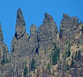 Mainmast
 East Peak
 West Peak
 pinnacle


References
- "Fifes Peaks, Washington". Peakbagger.com.
- "Fifes Peaks". Geographic Names Information System. United States Geological Survey, United States Department of the Interior. Retrieved 2018-08-12.
- USGS, Geological Survey Bulletin 1292
- "Mainmast, Washington". Peakbagger.com.
- "Cannonhole Pinnacle, Washington". Peakbagger.com.
- Beckey, Fred W. Cascade Alpine Guide, Climbing and High Routes. Seattle, WA: Mountaineers Books, 2008.
External links
- Fifes Peaks weather forecast
Другой контент может иметь иную лицензию. Перед использованием материалов сайта WikiSort.org внимательно изучите правила лицензирования конкретных элементов наполнения сайта.
WikiSort.org - проект по пересортировке и дополнению контента Википедии