geo.wikisort.org - Mountains
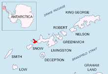
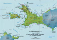
Enrique Hill (Bulgarian: хълм Енрике, ‘Halm Enrique’ \'h&lm en-'ri-ke\) is the ice-free hill rising to 156 m in Dospey Heights on the Ray Promontory of Byers Peninsula, Livingston Island in the South Shetland Islands, Antarctica. It surmounts Barclay Bay to the east and northeast, and Diomedes Lake on the southeast


The feature is part of the Antarctic Specially Protected Area ASPA 126 Byers Peninsula, situated in one of its restricted zones.[1]
The hill is named after the Jordi Enrique from Juan Carlos I Base who, together with Francesc Sàbat, made the first ascent of the island's summit Mount Friesland (1700 m) on 30 December 1991.
Location
Enrique Hill is located at 62°35′55.3″S 61°07′37.1″W, which is 1.54 km east-northeast of Dulo Hill, 850 m east-southeast of Battenberg Hill and 1.4 km northwest of Penca Hill. Spanish mapping in 1992, and Bulgarian in 2009 and 2017.
Maps
- Península Byers, Isla Livingston. Mapa topográfico a escala 1:25000. Madrid: Servicio Geográfico del Ejército, 1992.
- L.L. Ivanov et al. Antarctica: Livingston Island and Greenwich Island, South Shetland Islands. Scale 1:100000 topographic map. Sofia: Antarctic Place-names Commission of Bulgaria, 2005.
- L.L. Ivanov. Antarctica: Livingston Island and Greenwich, Robert, Snow and Smith Islands. Scale 1:120000 topographic map. Troyan: Manfred Wörner Foundation, 2009. ISBN 978-954-92032-6-4
- Antarctic Digital Database (ADD). Scale 1:250000 topographic map of Antarctica. Scientific Committee on Antarctic Research (SCAR). Since 1993, regularly upgraded and updated.
- L.L. Ivanov. Antarctica: Livingston Island and Smith Island. Scale 1:100000 topographic map. Manfred Wörner Foundation, 2017. ISBN 978-619-90008-3-0
Notes
- Management Plan for Antarctic Specially Protected Area No. 126 Byers Peninsula. Measure 4 (2016), ATCM XXXIX Final Report. Santiago, 2016
References
- Bulgarian Antarctic Gazetteer. Antarctic Place-names Commission. (details in Bulgarian, basic data in English)
- Enrique Hill. SCAR Composite Gazetteer of Antarctica
External links
- Enrique Hill. Copernix satellite image
This article includes information from the Antarctic Place-names Commission of Bulgaria which is used with permission.
На других языках
[de] Enrique Hill
Der Enrique Hill (englisch; bulgarisch хълм Енрике .mw-parser-output .Latn{font-family:"Akzidenz Grotesk","Arial","Avant Garde Gothic","Calibri","Futura","Geneva","Gill Sans","Helvetica","Lucida Grande","Lucida Sans Unicode","Lucida Grande","Stone Sans","Tahoma","Trebuchet","Univers","Verdana"}chalm Enrike) ist ein 156 m hoher und unvereister Hügel auf der Livingston-Insel im Archipel der Südlichen Shetlandinseln. Er ragt 1,53 km ostnordöstlich des Dulo Hill, 0,85 km ostsüdöstlich des Battenberg Hill und 1,4 km nordwestlich des Penca Hill in den Dospey Heights der Ray Promontory auf der Byers-Halbinsel auf. Die Barclay Bay liegt östlich und nordöstlich von ihm.- [en] Enrique Hill
Другой контент может иметь иную лицензию. Перед использованием материалов сайта WikiSort.org внимательно изучите правила лицензирования конкретных элементов наполнения сайта.
WikiSort.org - проект по пересортировке и дополнению контента Википедии