geo.wikisort.org - Mountains
Pico El Yunque or El Yunque Peak (Taíno: Yukiyu[1]) is a mountain that is located fully within the boundaries of the El Yunque National Forest, part of the U.S. Forest Service, which is the only tropical rainforest under the U.S. Forest Service jurisdiction. It is located in the municipality of Río Grande.
- This article refers to the mountain. For information on the national forest, see El Yunque National Forest. For the mountain in Cuba, see El Yunque.
| Pico El Yunque | |
|---|---|
View of El Yunque from the Yokahú Tower in Río Grande, Puerto Rico | |
| Highest point | |
| Elevation | 1,080 m (3,540 ft) |
| Parent peak | El Toro |
| Coordinates | 18°18′38″N 65°47′29″W |
| Naming | |
| Etymology | Yúcahu phonetic Spanish transliteration of Taíno possibly meaning 'white land' and/or El Yunque meaning 'the anvil' in Spanish due to the shape of the mountain range when seen from the south. |
| Geography | |
 Pico El Yunque Río Grande, Puerto Rico | |
| Parent range | Sierra de Luquillo |
| Climbing | |
| Easiest route | Hike |
Background
The peak itself, standing at 1,080 metres (3,540 feet) above sea level is not the highest in Puerto Rico or even the Sierra de Luquillo range where it is located. It is however the most famous peak due to its curious shape, its natural environment and history, and for its cultural importance to the Taino people. The peak is nearly always covered in thin mist and, due to its high humidity, a quick shower develops during some afternoons. The hike to the top from the Mina Falls is not challenging yet it takes almost 4+1⁄2 hours.
This peak is located on the El Yunque massif which also contains other smaller peaks such as Mount Britton, Juan Diego Peak and the Roca del Yunque which is a rocky peak close to the summit of El Yunque. El Yunque massif itself is part of the Sierra de Luquillo. The highest point in the Sierra de Luquillo is El Toro (Spanish for the bull) located in the municipal boundary between Río Grande and Las Piedras, which lends its name to the El Toro Wilderness.
Climate
El Yunque is classified as having a tropical rainforest climate, Köppen climate type 'Af', along with surrounding areas. The average temperature of the park is 70 °F, and seasonal variation virtually nonexistent. The rugged area can receive over 200 inches (5080 millimeters) of annual rainfall and is the rainiest of all US national forests.[2][3][4]
Gallery
 Morning mist in El Yunque rainforest by El Yunque peak.
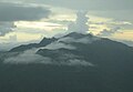 El Yunque massif with Pico El Yunque, Roca El Yunque and Mount Britton.
 El Yunque view from Mount Britton Tower.
 El Yunque from the north.
 El Yunque from Yocahu Tower.
 Los Picachos (left) and El Yunque (right) covered in fog.
 El Yunque from the Northeast Ecological Corridor.


See also
- El Yunque National Forest
References
- "Taino Petroglyphs on the Rio Blanco in Puerto Rico near Naguabo". elyunque.com. Retrieved October 20, 2021.
- "About the Forest MAIN". USDA Forest Service. Retrieved March 25, 2020. USDA Forest Service
- "Naguabo, Puerto Rico". weatherbase.com. Retrieved January 25, 2015.
- "El Yunque, Puerto Rico". welcome.topuertorico.org. Retrieved October 30, 2018.
External links
 Media related to El Yunque (Puerto Rico) at Wikimedia Commons
Authority control | |
|---|---|
| General |
|
| National libraries | |
На других языках
- [en] El Yunque (Puerto Rico)
[it] El Yunque (Porto Rico)
El Yunque è la più famosa montagna di Porto Rico, sebbene non sia la più alta. Si trova nella Sierra de Luquillo, una diramazione nord-orientale della catena montuosa della Cordillera Central, ed è localizzata nel comune di Luquillo. Dall'alto dei suoi 1.080 m domina la Foresta nazionale caraibica, a cui ha dato il nome di Bosque de El Yunque o El Yunque National Forest.Другой контент может иметь иную лицензию. Перед использованием материалов сайта WikiSort.org внимательно изучите правила лицензирования конкретных элементов наполнения сайта.
WikiSort.org - проект по пересортировке и дополнению контента Википедии