geo.wikisort.org - Mountains
Dorje Lhakpa is a mountain in the Jugal Himal, southeast of Langtang valley in Nepal.[1]
| Dorje Lhakpa | |
|---|---|
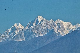
 Dorje Lhakpa seen from Dulalthok. | |
| Highest point | |
| Elevation | 6,966 m (22,854 ft)[1] |
| Prominence | 756 m (2,480 ft)[2] |
| Listing | Mountains of Nepal |
| Coordinates | 28°10′26″N 85°46′45″E[1] |
| Geography | |
 Dorje Lhakpa Location in Nepal | |
| Location | Langtang National Park, Nepal |
| Parent range | Himalayas |
| Climbing | |
| Easiest route | West Ridge |
Visible also from Kathmandu valley it has an elegant pyramid-shaped figure and is an ideal target for photographers and mountaineers. Considered by many of intermediate difficulty with easiest route from the west ridge. Its climb is offered by many trekking and mountaineering agencies in Nepal.
Climbing history
The first attempt and successful climb recorded is by a Japanese expedition in the late 1960s by the west ridge.
In 1986, a German–Nepalese expedition (Klaus Stark (leader of the expedition), Mathias Rau, Helmut Müller, Bernd Mayer (doctor), Thomas Oeser from T.A.K. (Turner-Alpen-Kränzchen), a German section of the DAV, German alpine club, and the Nepalese Joint-Members Ang Pasang (Sirdar) and Pemba Tharke) reached the mountain from the southern Balephi Khola and attempt to climb it over the west ridge. On July 11, 1986, Helmut Müller, Bernd Mayer reached the summit separately; Müller is forced to bivouac at 6,700 m (21,980 ft) while descending.[3]
Another attempt was made by a 7-member-team Italian expedition ADC89 during fall of 1989, again from the west ridge and approach from south. The climb was stopped after Camp 1 at approx 6100 m due to unstable snow and avalanche danger on the ridge.
In the following years (1991?) a German expedition successfully climbed the mountain again by the west ridge.
In 1992, Carlos Buhler made a solo climb of Dorje Lhakpa. Buhler did not intend initially to climb solo. The climb became a solo of the West Ridge after Carlos' partner, Jon Aylward, became ill at base camp. Buhler described the climb in the 1993 American Alpine Journal.[4]
Another successful expedition was a French team of four in 2001.
 |
 |
References
- Carter, H. A. (1985). "Classification of the Himalaya" (PDF). American Alpine Journal. 27 (59): 109–141.
- "Dorje Lhakpa". Peakbagger.com. Retrieved 15 June 2020.
- Oeser, Thomas (1987). "Dorje Lhakpa". American Alpine Journal. American Alpine Club. Retrieved 15 June 2020.
- Buhler, Carl (1993). "Alone on Dorje Lhakpa". American Alpine Journal. American Alpine Club. 35 (67). Retrieved 15 June 2020.
External links
- View from Nagarkot, Nepal
- Climb short description
- 2001 successful climb description[permanent dead link]
На других языках
[de] Dorje Lhakpa
Der Berg Dorje Lhakpa befindet sich in einer Bergkette im Zentral-Himalaya südlich des Flusstals des Langtang Khola in der nepalesischen Verwaltungszone Bagmati.- [en] Dorje Lhakpa
[fr] Dorje Lhakpa
Le Dorje Lhakpa est un sommet népalais se situant en Himalaya. Il culmine à 6 966 mètres d'altitude.[it] Dorje Lhakpa
Dorje Lhakpa (6966 m) è una montagna nella regione del Langtang Himal in Nepal, vicino al confine con la regione Autonoma del Tibet.[1]Другой контент может иметь иную лицензию. Перед использованием материалов сайта WikiSort.org внимательно изучите правила лицензирования конкретных элементов наполнения сайта.
WikiSort.org - проект по пересортировке и дополнению контента Википедии