geo.wikisort.org - Mountains
The Dietzenley in the county of Vulkaneifel in the German state of Rhineland-Palatinate is a mountain, 617.6 m above sea level (NHN),[1] and the highest point in the Pelm Forest, a part of the Volcanic Eifel range.
| Dietzenley | |
|---|---|
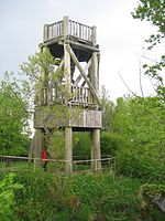
 Viewing tower on the Dietzenley | |
| Highest point | |
| Elevation | 617.6 m above sea level (NHN) (2,026 ft) [1] |
| Coordinates | 50°12′09″N 6°40′40″E |
| Geography | |
 Dietzenley Vulkaneifel county, Rhineland-Palatinate, Germany (Viewing tower at the summit) | |
| Parent range | Volcanic Eifel |
| Geology | |
| Mountain type | volcano |
| Type of rock | Basalt |
The Dietzenley rises within the Volcanic Eifel Nature Park in the parish of Gerolstein north and above the Gerolstein quarter of Büscheich-Niedereich.
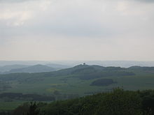
On the largely wooded domed summit stands a small, wooden observation tower, which offers a good view of the Volcanic Eifel. Somewhat below it there is an electrical converter and the remains of a Celtic ringwall.
The Dietzenley may be reached on footpaths from Gerolstein, Pelm or Gees.

References
На других языках
[de] Dietzenley
Die Dietzenley im Landkreis Vulkaneifel in Rheinland-Pfalz ist mit 617,6 m ü. NHN[1] der höchste Berg des zur Vulkaneifel gehörenden Pelmer Waldes.- [en] Dietzenley
Текст в блоке "Читать" взят с сайта "Википедия" и доступен по лицензии Creative Commons Attribution-ShareAlike; в отдельных случаях могут действовать дополнительные условия.
Другой контент может иметь иную лицензию. Перед использованием материалов сайта WikiSort.org внимательно изучите правила лицензирования конкретных элементов наполнения сайта.
Другой контент может иметь иную лицензию. Перед использованием материалов сайта WikiSort.org внимательно изучите правила лицензирования конкретных элементов наполнения сайта.
2019-2025
WikiSort.org - проект по пересортировке и дополнению контента Википедии
WikiSort.org - проект по пересортировке и дополнению контента Википедии