 Sign at the beginning of the path
 Mount Actaeon, topped by a Norfolk pine
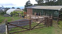 The endemic plant nursery
 path to Halley's Observatory from below Mt. Actaeon
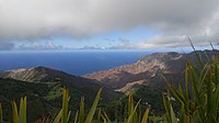 view of Sandy Bay from below Mt. Actaeon
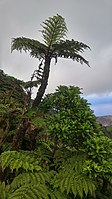 Tree fern and black cabbage tree
 Norfolk Pines on Cuckhold's Point and Mt. Actaeon
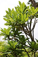 Cabbage trees
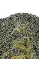 Stairs to Diana's Peak
 Panoramic view from Diana's Peak
geo.wikisort.org - Mountains
Diana's Peak is the highest point, at 818 metres (2,684 ft), on the island of Saint Helena, a British overseas territory in the South Atlantic Ocean.[1] It is of volcanic origin. The mountain and its surroundings with a total area of 81 ha were proclaimed a national park in March 1996, the first on the island.[2] It is a preserve of several endangered endemic species, including tree fern, he cabbage and black cabbage trees, and whitewood.[3] The park contains walking paths connecting the peaks - Mt. Actaeon (814m), Diana's Peak and Cuckold's Point (815m). The two shorter peaks are topped by large Norfolk pines. On the northern slopes there is a nursery for endemic species.
| Diana's Peak | |
|---|---|
 Diana's Peak and Cuckold's Point | |
| Highest point | |
| Elevation | 818 m (2,684 ft) |
| Prominence | 818 m (2,684 ft) |
| Coordinates | 15°57′35″S 5°41′29″W |
| Geography | |
| Location | Saint Helena, South Atlantic Ocean |
The peak is located at the tripoint where the districts of Sandy Bay (southwest), Levelwood (east) and Longwood (north) meet. The closest settlements are Bamboo Hedge (the main settlement of Sandy Bay District), Hutt's Gate (in Longwood District) and Levelwood Village.
Gallery


See also
- List of mountains and hills of Saint Helena, Ascension and Tristan da Cunha
- Geography of Saint Helena
References
- EPIC. "Homepage". Botanic Gardens Conservation International. Retrieved 1 November 2019.
- "St Helena - the Grand Tour - Diana's Peak". Sthelena. Retrieved 1 November 2019.
- EPIC. "Homepage". Botanic Gardens Conservation International. Retrieved 1 November 2019.
This article about a location in Saint Helena is a stub. You can help Wikipedia by expanding it. |
На других языках
[de] Diana’s Peak
Der Diana’s Peak auf der Insel St. Helena ist mit einer Höhe von 818 m der höchste Berg der Insel. Er ist vulkanischen Ursprungs[1] und liegt im Distrikt Sandy Bay.- [en] Diana's Peak
[fr] Pic de Diana
Le pic de Diana (en anglais : Diana's Peak) est le point culminant, à 818 mètres, de l'île de Sainte-Hélène dans les territoires britanniques d'outre-mer de Sainte-Hélène, Ascension et Tristan da Cunha. Les 81 ha entourant le sommet ont été déclarés parc national du Pic de Diana en 1996[1],[2].[ru] Дайанас-Пик
Дайанас-Пик (англ. Diana's Peak) — наивысшая точка острова Святой Елены, Британской заморской территории в южной части Атлантического океана[2]. Высота пика 823[3] метра, он имеет вулканическое происхождение[4].Текст в блоке "Читать" взят с сайта "Википедия" и доступен по лицензии Creative Commons Attribution-ShareAlike; в отдельных случаях могут действовать дополнительные условия.
Другой контент может иметь иную лицензию. Перед использованием материалов сайта WikiSort.org внимательно изучите правила лицензирования конкретных элементов наполнения сайта.
Другой контент может иметь иную лицензию. Перед использованием материалов сайта WikiSort.org внимательно изучите правила лицензирования конкретных элементов наполнения сайта.
2019-2026
WikiSort.org - проект по пересортировке и дополнению контента Википедии
WikiSort.org - проект по пересортировке и дополнению контента Википедии