geo.wikisort.org - Mountains
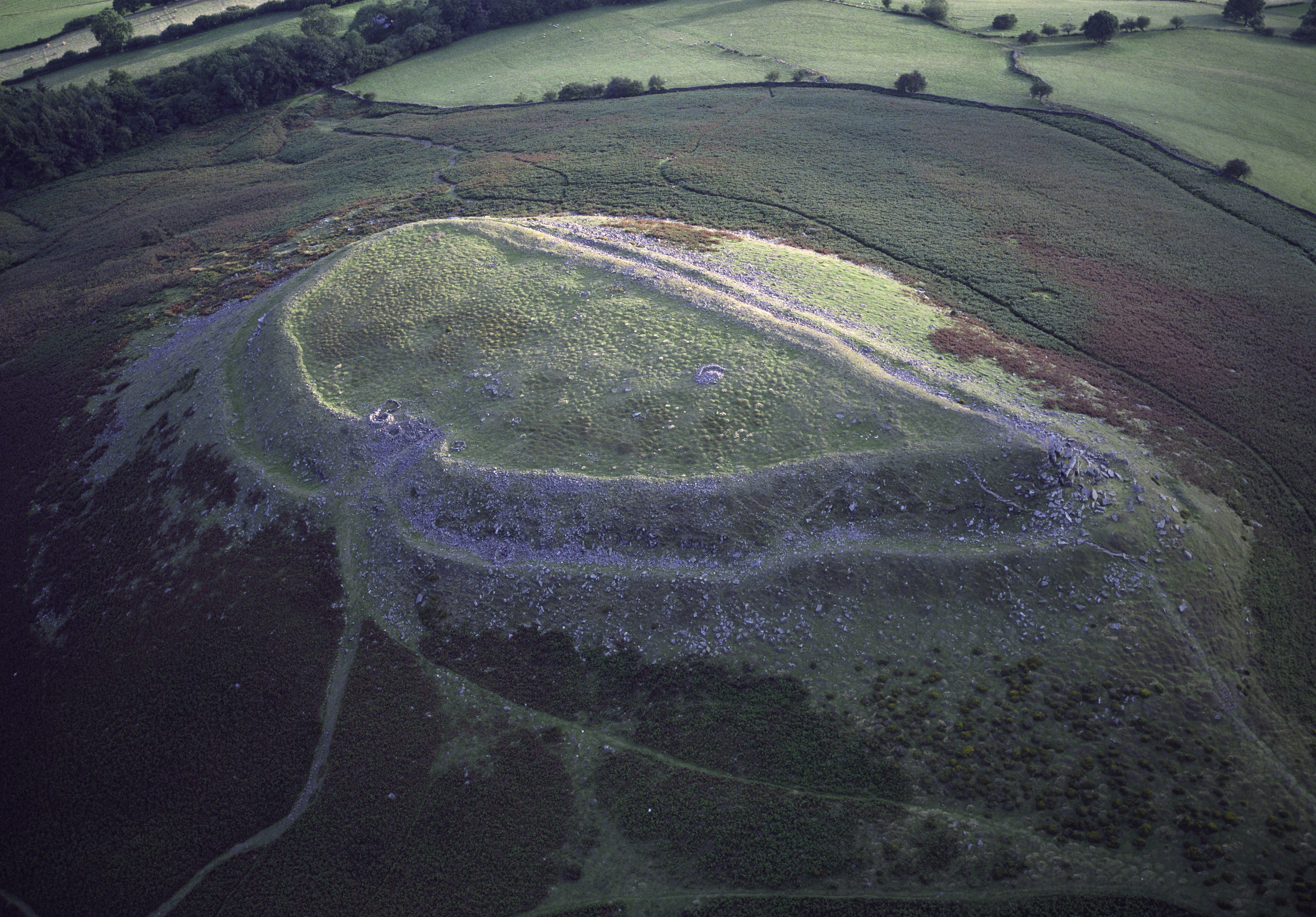
Crug Hywel is an Iron Age Celtic hillfort,[1] with a clearly visible earth and stone ditch and rampart.[2] Crug Hywel is approached by a couple of public footpaths across farmland from Crickhowell and Llanbedr and visited by the Beacons Way. It lies within an area designated as open country over which the public have the right to roam.
| Crug Hywel | |
|---|---|
 Crug Hywel, Black Mountains | |
| Highest point | |
| Elevation | 451 m (1,480 ft) |
| Prominence | < 10 m |
| Naming | |
| English translation | Hywel's mound |
| Language of name | Welsh |
| Pronunciation | Welsh: [ˈkriːɡ ˈhɐwɛl] |
| Geography | |
| Location | Black Mountains, Wales |
| OS grid | SO225207 |
The name is sometimes given to the flat-topped hill itself, which is also called Table Mountain in English). Located at the southern edge of the Black Mountains in south-east Wales, it rises to 451 m above sea level, from the southern flank of Pen Cerrig-calch (701 m), and overlooks the town of Crickhowell, whose name derives from Crug Hywel.[1]
The Welsh name Mynydd y Begwn is also used of this summit. As a result, it has been suggested that the name Crug Hywel (which means 'Hywel's mound') may originally have referred to the castle mound in Crickhowell.[3]
Geology

The hill is formed from Old Red Sandstone originating in the Devonian period, specifically the sandstones of the Brownstones Formation, topped by rocks of the Quartz Conglomerate Group. The whole mass of rocks forming this outlier of Pen Cerrig-calch can readily be seen to dip more sharply to the south than nearby strata and is considered to be an excellent example of a translational slide.[4]
See also
- List of hillforts in Wales
References
- "Crickhowell to Table Mountain". Brecon Beacons National Park Authority. Retrieved 22 January 2016.
- "Crug Hywel Camp". Royal Commission on the Ancient and Historical Monuments of Wales. 9 May 2007. Retrieved 22 January 2016.
- Hywel Wyn Owen and Richard Morgan, Dictionary of the Place-Names of Wales (Llandysul: Gomer Press, 2007), p. 102.
- Barclay, W.J. & Wilby, P.R. 2003,Geology of the Talgarth district, BGS 1:50K map geological sheet explanation
External links
- Aerial photograph of Crug Hywel (Casglu'r Tlysau)
- 3D model of Crug Hywel hillfort
This Powys location article is a stub. You can help Wikipedia by expanding it. |
На других языках
[de] Crug Hywel
Crug Hywel (walisisch), die englische Bezeichnung lautet Table Mountain, (deutsch „Tafelberg“) ist ein 451 m hoher, abgeflachter Hügel am südlichen Rande der Black Mountains in Wales im Brecon Beacons National Park. Er liegt an der Südflanke des 701 m hohen Pen Cerrig-calch und überragt die im Süden liegende Stadt Crickhowell, von der er seinen Namen hat.- [en] Crug Hywel
Другой контент может иметь иную лицензию. Перед использованием материалов сайта WikiSort.org внимательно изучите правила лицензирования конкретных элементов наполнения сайта.
WikiSort.org - проект по пересортировке и дополнению контента Википедии