geo.wikisort.org - Mountains
Crown Point is a mountain with a summit elevation of 11,346 feet (3,458 m) located in the Sierra Nevada mountain range, in Mono County of northern California, United States.[3] The summit is set in the Hoover Wilderness on land managed by Humboldt–Toiyabe National Forest, whereas the lower southwest slope is set within Yosemite National Park and Tuolumne County. The peak is situated approximately five miles southwest of Twin Lakes, one mile southeast of Peeler Lake, three miles southeast of Kettle Peak, and 4.3 miles (6.9 km) west-northwest of Matterhorn Peak. Topographic relief is significant as the northeast aspect rises over 2,100 feet (640 meters) above the Robinson Lakes in one mile. The first ascent of the summit was made in 1905 by George R. Davis, Albert Hale Sylvester, and Pearson Chapman, all with the United States Geological Survey.[5]
| Crown Point | |
|---|---|
 Crown Point reflected in Peeler Lake | |
| Highest point | |
| Elevation | 11,346 ft (3,458 m)[1] |
| Prominence | 1,306 ft (398 m)[1] |
| Parent peak | Eocene Peak[1] |
| Isolation | 2.18 mi (3.51 km)[1] |
| Listing | Vagmarken Club Sierra Crest List[2] |
| Coordinates | 38°06′39″N 119°27′27″W[3] |
| Geography | |
 Crown Point  Crown Point | |
| Location | Mono and Tuolumne counties, California, U.S. |
| Parent range | Sierra Nevada |
| Topo map | USGS Matterhorn Peak |
| Geology | |
| Age of rock | Cretaceous |
| Mountain type | Fault block |
| Type of rock | Metamorphic rock |
| Climbing | |
| First ascent | 1905 by George R. Davis, A.H. Sylvester and Pearson Chapman[4] |
| Easiest route | Simple scramble, (class 2)[4] |
Climate
According to the Köppen climate classification system, Crown Point is located in an alpine climate zone.[6] Most weather fronts originate in the Pacific Ocean, and travel east toward the Sierra Nevada mountains. As fronts approach, they are forced upward by the peaks, causing moisture in the form of rain or snowfall to drop onto the range (orographic lift). Precipitation runoff from this mountain drains into headwaters of Robinson Creek which is a tributary of the Walker River, as well as west into Rancheria Creek which is a Tuolumne River tributary.
Gallery
 Crown Point with Peeler Lake
 Crown Point from Barney Lake
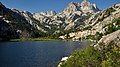 From Barney Lake
 Northwest aspect
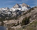 NNE aspect
 From Peeler Lake
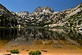 From Barney Lake


See also
References
- "Crown Point, California". Peakbagger.com. Retrieved 2021-05-15.
- "Vagmarken Sierra Crest List". Angeles Chapter, Sierra Club. Retrieved 2021-11-17.
- "Crown Point". Geographic Names Information System. United States Geological Survey. Retrieved 2021-05-15.
- Secor, R.J. (1992). The High Sierra Peaks, Passes, and Trails (1st ed.). Seattle: The Mountaineers. pp. 350–351. ISBN 978-0898863130.
- Swift, Robert L.; Nelson, David A. (1954). "A Climber's Guide to the High Sierra".
- Peel, M. C.; Finlayson, B. L.; McMahon, T. A. (2007). "Updated world map of the Köppen−Geiger climate classification". Hydrol. Earth Syst. Sci. 11. ISSN 1027-5606.
External links
- Weather forecast: Crown Point
Другой контент может иметь иную лицензию. Перед использованием материалов сайта WikiSort.org внимательно изучите правила лицензирования конкретных элементов наполнения сайта.
WikiSort.org - проект по пересортировке и дополнению контента Википедии