geo.wikisort.org - Mountains
Coyote Buttes is a section of the Paria Canyon-Vermilion Cliffs Wilderness managed by the Bureau of Land Management (BLM), spanning extreme south-central Utah and north-central Arizona, south of US 89 halfway between Kanab, Utah and Page, Arizona. It is divided into two areas: Coyote Buttes North and Coyote Buttes South. Visiting either of the Coyote Buttes areas requires purchasing a hiking permit.

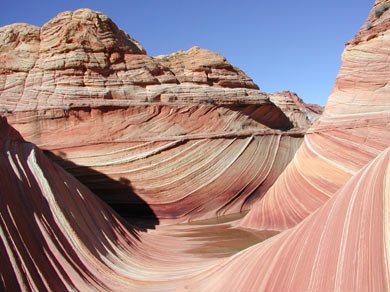
The Coyote Buttes area is an exposure of cross-bedded aeolian Jurassic Navajo Sandstone.[1] The variable coloration of the sandstones is a result of various iron oxide pigments within the layers. A dinosaur trackway or trample surface is found in the area and provides evidence of a variety of dinosaurs.[1] The area includes dramatic swirling erosional rock formations such as The Wave.
The Wave and Buckskin Gulch share the Wire Pass Trailhead on House Rock Valley Road.
Dinosaur trackway
The dinosaur trackway within the area is a site of 0.75 acres (3,000 m2) that has densely packed dinosaur footprints within the area. The trackway contains more than 1,000 footprints which were made approximately 190 million years ago.[2] Tracks of three genera of Eubrontes, Anchisauripus and Grallator are present along with a Sauropodomorph that has not been identified.[1]
Gallery
 Coyote Buttes
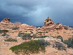 Coyote Buttes
 The Wave
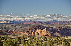 Looking north past the teepees, in Coyote Buttes South


References
- Seiler, W. M. (2008), Jurassic Navajo sandstone of Coyote Buttes, Utah/Arizona: coloration and diagenetic history, preservation of a dinosaur trample surface, and terrestrial analogs to Mars (MS Thesis), The University of Utah
- "Scientists Discover 'Dinosaur Dance Floor'". The Washington Post. October 22, 2008. p. KidsPost.
External links
- "Coyote Buttes". Geographic Names Information System. United States Geological Survey.
- "Bureau of Land Management website". Archived from the original on 2012-04-13., with information on hiking permits
- "The Wave (Coyote Buttes)". SummitPost.org.
На других языках
[de] Coyote Buttes
Die Coyote Buttes sind ein größtenteils im Vermilion Cliffs National Monument gelegener Gebirgszug, sie erstrecken sich über die US-Bundesstaaten Arizona und – im nördlichsten Teil – Utah.- [en] Coyote Buttes
[fr] Buttes Coyote
Les buttes Coyote (en anglais : Coyote Buttes) sont une formation montagneuse des États-Unis située sur le plateau du Colorado.[it] Coyote Buttes
Coyote Buttes è una sezione del Paria Canyon-Vermilion Cliffs Wilderness gestita dal Bureau of Land Management (BLM), che si abbraccia l'estremo Utah centro-meridionale e l'Arizona centro-settentrionale, a sud dell'autostrada US 89 a metà strada tra Kanab, Utah e Page, Arizona. È diviso in due aree: Coyote Buttes North e Coyote Buttes South. Visitare una delle aree di Coyote Buttes richiede l'acquisto di un permesso escursionistico.[ru] Склон Койот-Бют
Склон Койот-Бют (англ. Coyote Buttes) — одна из самых популярных природных достопримечательностей плато Колорадо. Он начал формироваться почти двести миллионов лет назад, во времена Юрского периода. Оранжево-красные дюны, состоят из мягкого песчаника, благодаря высокому содержанию кальция в почве, они уплотнились, а дожди и ветра создали плавные кривые, образовав природные закручивающиеся спирали. На северном участке склона, где находится «Волна» (The Wave) — дугообразная впадина, рельефные изгибы которой напоминают движения ветра, можно наблюдать самые драматичные ландшафты.Другой контент может иметь иную лицензию. Перед использованием материалов сайта WikiSort.org внимательно изучите правила лицензирования конкретных элементов наполнения сайта.
WikiSort.org - проект по пересортировке и дополнению контента Википедии