geo.wikisort.org - Mountains
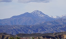
Cobblestone Mountain is a peak in the Topatopa Mountains, in Ventura County, several miles north of Piru, California. At 6,738 feet (2,054 m), it is the second highest peak of the Topatopa Mountains after Alamo mountain, and followed by Hines Peak.[2] Snow frequently falls on the mountain during winter.
| Cobblestone Mountain | |
|---|---|
 View of the mountain's eastern face | |
| Highest point | |
| Elevation | 6,738 ft (2,054 m) NAVD 88[1] |
| Prominence | 1,373 ft (418 m)[2] |
| Listing | Sierra Club Hundred Peaks Section[3] |
| Coordinates | 34°36′32″N 118°52′04″W[1] |
| Geography | |
| Location | Ventura County California, U.S. |
| Parent range | Topatopa Mountains Transverse Ranges |
| Topo map | USGS Cobblestone Mountain |
| Climbing | |
| Easiest route | Hike[3] |
When viewing the Topatopa Mountains from the east, Cobblestone Mountain is the most visibly prominent mountain of the entire range.
The peak is in the Sespe Wilderness, which is part of the Los Padres National Forest.

See also
- Topatopa Mountains
- Los Padres National Forest
- Transverse Ranges
- Hines Peak
References
- "Cobblestone". NGS data sheet. U.S. National Geodetic Survey. Retrieved 2014-03-02.
- "Cobblestone Mountain, California". Peakbagger.com. Retrieved 2014-03-02.
- "Cobblestone Mountain". Hundred Peaks Section List. Angeles Chapter, Sierra Club. Retrieved 2014-02-23.
Текст в блоке "Читать" взят с сайта "Википедия" и доступен по лицензии Creative Commons Attribution-ShareAlike; в отдельных случаях могут действовать дополнительные условия.
Другой контент может иметь иную лицензию. Перед использованием материалов сайта WikiSort.org внимательно изучите правила лицензирования конкретных элементов наполнения сайта.
Другой контент может иметь иную лицензию. Перед использованием материалов сайта WikiSort.org внимательно изучите правила лицензирования конкретных элементов наполнения сайта.
2019-2025
WikiSort.org - проект по пересортировке и дополнению контента Википедии
WikiSort.org - проект по пересортировке и дополнению контента Википедии