geo.wikisort.org - Mountains
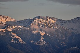
The Chüemettler (1,703 metres (5,587 ft)) is a mountain of the Appenzell Alps, overlooking the Walensee in the canton of St. Gallen. It lies south of the Speer and southeast of the Federispitz mountains. Chüe literally means cows in Swiss-German language, Mettler is a family name respectively a term used as name of several local areas.
| Chüemettler | |
|---|---|
 as seen from the Obersee lake shore respectively towards Kempraten | |
| Highest point | |
| Elevation | 1,703 m (5,587 ft) |
| Prominence | 99 m (325 ft)[1] |
| Parent peak | Speer and Federispitz |
| Isolation | 0.68 km (0.42 mi) |
| Coordinates | 47°10′47″N 9°5′46″E |
| Geography | |
| Location | St. Gallen, Switzerland |
| Parent range | Appenzell Alps |
References
- Retrieved from the Swisstopo topographic maps (1:25,000). The key col is the Furggli (1,604 m).
External links
| Wikimedia Commons has media related to Chüemettler. |
На других языках
[de] Chüemettler
Der Chüemettler ist eine Bergspitze auf einer Höhe von 1704 m ü. M. in den sanktgallisch Alpen auf dem Gebiet der Ortsgemeinde Rüttiberg in der politischen Gemeinde Schänis.- [en] Chüemettler
Текст в блоке "Читать" взят с сайта "Википедия" и доступен по лицензии Creative Commons Attribution-ShareAlike; в отдельных случаях могут действовать дополнительные условия.
Другой контент может иметь иную лицензию. Перед использованием материалов сайта WikiSort.org внимательно изучите правила лицензирования конкретных элементов наполнения сайта.
Другой контент может иметь иную лицензию. Перед использованием материалов сайта WikiSort.org внимательно изучите правила лицензирования конкретных элементов наполнения сайта.
2019-2025
WikiSort.org - проект по пересортировке и дополнению контента Википедии
WikiSort.org - проект по пересортировке и дополнению контента Википедии