geo.wikisort.org - Mountains
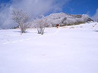
Chausuyama (茶臼山, Mount Chausu) is a mountain located on the border between Aichi and Nagano Prefectures, with its highest point on the Aichi side. With a height of 1,415.2 metres (4,643 ft), it is the tallest peak within Aichi Prefecture. The mountain is within the borders of the Tenryū-Okumikawa Quasi-National Park. During wintertime, the area hosts a popular ski resort.

See also
- Tenryū-Okumikawa Quasi-National Park
External links
- Topographical Map Archived 2012-03-26 at the Wayback Machine

| Wikimedia Commons has media related to Mount Chausu (Aichi and Nagano). |
На других языках
- [en] Chausuyama (Aichi)
[fr] Mont Chausu
Le mont Chausu (茶臼山, Chausuyama?) est une montagne s'élevant à 1 416 m d'altitude au Japon, à la frontière entre la préfecture d'Aichi, dont il est le point culminant, et la préfecture de Nagano. Il est situé dans le parc quasi national de Tenryū-Okumikawa depuis sa création en 1969.[it] Chasuyama
Il Chausuyama (茶臼山?) (Monte Chausu) è una montagna situata al confine tra le prefetture di Aichi e di Nagano, con il punto più alto nel lato di Aichi.Текст в блоке "Читать" взят с сайта "Википедия" и доступен по лицензии Creative Commons Attribution-ShareAlike; в отдельных случаях могут действовать дополнительные условия.
Другой контент может иметь иную лицензию. Перед использованием материалов сайта WikiSort.org внимательно изучите правила лицензирования конкретных элементов наполнения сайта.
Другой контент может иметь иную лицензию. Перед использованием материалов сайта WikiSort.org внимательно изучите правила лицензирования конкретных элементов наполнения сайта.
2019-2025
WikiSort.org - проект по пересортировке и дополнению контента Википедии
WikiSort.org - проект по пересортировке и дополнению контента Википедии
