geo.wikisort.org - Mountains
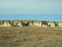
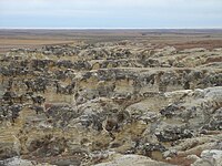
Castle Rock is a 70 ft (21 m) tall chalk pillar landmark in Gove County, Kansas, United States. The formation and the nearby badlands are located in the Smoky Hills region of Kansas, which is approximately 11 mi (18 km) south of I-70 near Quinter, Kansas.
| Castle Rock | |
|---|---|
 Castle Rock in 2005 | |
| Highest point | |
| Elevation | 2,434 ft (742 m)[1] |
| Prominence | 70 ft (21 m) |
| Coordinates | 38°51′40″N 100°10′11″W[1] |
| Geography | |
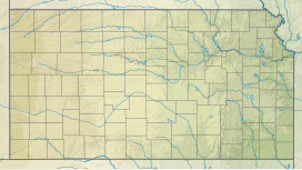 Castle Rock Location in Kansas  Castle Rock Castle Rock (the United States) | |
| Geology | |
| Age of rock | Cretaceous |
| Mountain type | Erosional remnant |
Description
Castle Rock was a landmark on the Butterfield Overland Despatch route (Overland Trail). The chalk was deposited in the area by an ancient inland sea.[2] The formation was carved by the weathering of the chalk by wind and water. It received its name because it is said to look like a castle rising above the prairie.
Weathering of the rock formation is increasing due to visitors climbing on the rocks. In 2001, following a thunderstorm, the tallest spire fell.[3]
On January 29, 2008, Castle Rock and Monument Rocks 31 miles to the west were jointly named as one of the 8 Wonders of Kansas.
Images
 Castle Rock, 1867
 Castle Rock, 2009
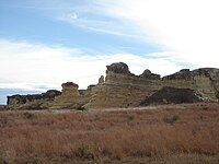


See also
- Big Basin Prairie Preserve
- Little Jerusalem Badlands State Park
- Monument Rocks (Kansas)
- Mushroom Rock State Park
- Rock City, Kansas
References
- "Castle Rock". Geographic Names Information System. United States Geological Survey, United States Department of the Interior.
- "Believe it or not: dry western Kansas is the place to study prehistoric oceans". National Public Radio. August 16, 2022. Retrieved 2022-10-04.
- "Castle Rock". Kansas Geological Survey. Retrieved 2022-10-04.
Further reading
- Kansas : A Cyclopedia of State History, Embracing Events, Institutions, Industries, Counties, Cities, Towns, Prominent Persons, Etc; 3 Volumes; Frank W. Blackmar; Standard Publishing Co; 944 / 955 / 824 pages; 1912. (Volume1 - Download 54MB PDF eBook),(Volume2 - Download 53MB PDF eBook), (Volume3 - Download 33MB PDF eBook)
External links
Другой контент может иметь иную лицензию. Перед использованием материалов сайта WikiSort.org внимательно изучите правила лицензирования конкретных элементов наполнения сайта.
WikiSort.org - проект по пересортировке и дополнению контента Википедии