geo.wikisort.org - Mountains
The Caraballo Mountains is a mountain range in the central part of Luzon island in the Philippines, situated between the Cordillera Central and Sierra Madre mountain ranges. The mountains serve as the location of the headwaters of the Cagayan River, the longest in the country.
| Caraballo Mountains | |
|---|---|
 The mountains as seen from the Umingan-Lupao border | |
| Highest point | |
| Peak | Mount Kiligantian |
| Elevation | 1,673 m (5,489 ft) |
| Dimensions | |
| Length | 54 km (34 mi) north-south |
| Width | 15 mi (24 km) |
| Area | 1,300 km2 (500 sq mi) |
| Geography | |
 | |
| Country | Philippines |
| Provinces |
|
| Range coordinates | 16°8′37.8″N 121°10′4.8″E |
| Borders on |
|
Several portions of the mountain range are protected under the National Integrated Protected Areas System, including the Casecnan Protected Landscape and the Pantabangan–Carranglan Watershed Forest Reserve.
Gallery
 A section of the range at Dupax del Sur
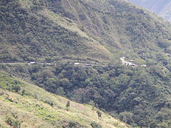 Dalton Pass in Santa Fe
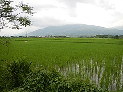 Another view from the fields of eastern Pangasinan
 Another view overlooking Dalton Pass


See also
- Geography of the Philippines
- Battle for the Villa Verde Trail
Wikimedia Commons has media related to Caraballo Mountains.
Authority control | |
|---|---|
| General |
|
| National libraries | |
This article about a location in the Philippines is a stub. You can help Wikipedia by expanding it. |
На других языках
[de] Caraballo-Berge
Die Caraballo-Berge (spanisch Monte Caraballo oder Sierra de Caraballo) sind ein Gebirge auf den Philippinen. Es befindet sich in der zentralen nördlichen Region der Insel Luzon und umfasst Gebiete der Provinzen Nueva Vizcaya und Quirino. Es bildet den zentralen Gebirgsknoten der Insel und erreicht eine Höhe von ca. 1680 Metern über dem Meeresspiegel.- [en] Caraballo Mountains
[es] Montes Caraballo
La sierra de Caraballo,[1] (también llamados montes Caraballo[2]), constituyen una cadena montañosa en la parte central de Luzón, en el norte del país asiático de las Filipinas. Se encuentran ubicados entre la Cordillera Central y la cordillera de la Sierra Madre, a 16° 11′ 8″ N, 121° 8′ 39″ E. En estas montañas de Caraballo se encuentran las cabeceras del río Cagayán.Текст в блоке "Читать" взят с сайта "Википедия" и доступен по лицензии Creative Commons Attribution-ShareAlike; в отдельных случаях могут действовать дополнительные условия.
Другой контент может иметь иную лицензию. Перед использованием материалов сайта WikiSort.org внимательно изучите правила лицензирования конкретных элементов наполнения сайта.
Другой контент может иметь иную лицензию. Перед использованием материалов сайта WikiSort.org внимательно изучите правила лицензирования конкретных элементов наполнения сайта.
2019-2026
WikiSort.org - проект по пересортировке и дополнению контента Википедии
WikiSort.org - проект по пересортировке и дополнению контента Википедии