geo.wikisort.org - Mountains
Calver Hill is a fell in the Yorkshire Dales National Park in North Yorkshire, England. It is composed of limestone[4] and is situated at grid reference NZ012003, near where the valleys of Swaledale and Arkengarthdale meet, the village of Reeth is located on its lower south-eastern slopes, it reaches an altitude of 487 metres (1,598 ft) and is a distinguished feature in mid Swaledale.[2][5][6][7] Calver Hill is an area of grouse shooting and the fell is dotted with grouse butts. Most of the drainage from the fell goes north and easterly to join the Arkle Beck in lower Arkengarthdale which eventually joins the River Swale just south of Reeth.
| Calver Hill | |
|---|---|
| Mount Calva Mount Calvey (archaic) | |
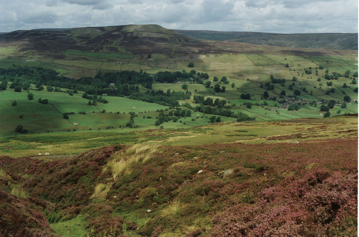
 Calver Hill seen from Fremington Edge | |
| Highest point | |
| Elevation | 487 m (1,598 ft) |
| Prominence | 90 m (300 ft)[1] |
| Coordinates | 54.397°N 1.980°W[2] |
| Geography | |
| Location | Swaledale, North Yorkshire |
| Country | England |
| OS grid | NZ012003[3] |
History
Evidence exits on the slopes of Calver Hill that point to use during the Neolithic Period and the Bronze Age. Finds of arrowheads, flints, and field patterns also point to possible areas of habitation.[8] The whole area of Calver Hill is sometimes referred to as Reeth Low Moor, and in some older texts, the name of the hill is recorded as either Mount Calvey, or Calvey Hill. Another alternative name of Mount Calva persists into the modern day.[9][10][11]
Older versions of the 1:25,000 Ordnance Survey map show a trig point at the summit of Calver Hill but all there is now is a pile of rubble and mining spoil to form a summit cairn. The fell is littered with signs of Calver Hill’s industrial past; there is a large disused quarry 500 metres (1,600 ft) north-west of the summit cairn, there are also disused tips, pits and shafts from former lead mines. Lead mining reached its heyday in the 19th century in this area and they were some of the most productive mines in Yorkshire. Calver Hill was a Bole hill a place where the lead from the mines was smelted in an open air furnace which used the prevailing wind to increase the heat.[12] Burnt stones and a scattering of slag show the locations of these furnaces.[13][14]
In January 1868, the disposal of some nitro-glycerine on top of the hill caused some worry in nearby Reeth and Arkengarthdale as the local population were not informed of the impending explosion. The blast caused debris to extend over 200 yards (180 m) our from the centre, and local people thought they were under attack.[15]
Walks
This section does not cite any sources. (September 2022) |
Calver Hill can be climbed from Reeth or from Langthwaite and Arkle Town in Arkengarthdale. From Reeth, Skelgate Lane is taken from just to the west of the village, this climbs through farmland until the open fell is reached at a height of 300 metres (980 ft), the western ridge is then followed to the summit of the fell.
From Arkengarthdale, the Arkle Town to Healaugh bridleway can be used to attain the western ridge at a height of 420 metres (1,380 ft); it is then a simple walk to reach the top.
References
- "Calver Hill". myyorkshiredales.co.uk. Retrieved 1 October 2021.
- "Reeth Low Moor Richmondshire (or Calver Hill)". getoutside.ordnancesurvey.co.uk. Retrieved 1 October 2021.
- "OL30" (Map). Yorkshire Dales – Northern & Central Area. 1:25,000. Explorer. Ordnance Survey. 2016. ISBN 978-0-319-26335-8.
- "The Rivers, Mountains and Sea Coast of Yorkshire", John Phillips, States that Calver Hill is composed of limestone.
- SAA 2002, p. 8.
- Laurie 2011, p. 42.
- "Whats on – Walks Calver Hill, Healaugh and the River Swale". Newsbank. 14 February 2013. Retrieved 1 October 2021.
- SAA 2002, p. 2.
- Speight 1897, p. 239.
- Gray, W (1836). Heights of the mountains of Yorkshire. York: Bellerby. p. 6. OCLC 703932369.
- Brown, Jonathan (23 October 2011). "My cruise to Booze up the lane deemed too dangerous for postmen". The Independent. Retrieved 1 October 2021.
- Neaveson, Peter; Palmer, Marylin (1994). Industry in the Landscape, 1700–1900. London: Routledge. p. 83. ISBN 1134832206.
- "Industry in the Landscape 1700 - 1900", Marilyn Palmer & Peter Neaverson, ISBN 0-415-11206-0 Gives information on lead smelting.
- "Ordnance Survey Outdoor Leisure Map 30 (Yorkshire Dales North & Central)", ISBN 0-319-23661-7 Gives information on quarrying and mining locations.
- Lloyd, Chris (26 January 2018). "On This Day, January 26: Risks faced by early air pioneers illustrated by 1918 fatal accident". Newsbank. Retrieved 1 October 2021.
Sources
- Laurie, M (2011). "Archaelogical Landscapes of Reeth Moor". Memoirs. Sheffield: The Northern Mines Research Society. 92. ISSN 0308-2199.
- Speight, Harry (1897). Romantic Richmondshire: Being a complete account of the history, antiquities and scenery of the picturesque valleys of the Swale and Yore. London: E Stock. OCLC 252008733.
- Swaledale and Arkengarthdale (PDF). archive.yorkshiredales.org.uk (Report). 2002. Retrieved 1 October 2021.
Другой контент может иметь иную лицензию. Перед использованием материалов сайта WikiSort.org внимательно изучите правила лицензирования конкретных элементов наполнения сайта.
WikiSort.org - проект по пересортировке и дополнению контента Википедии