geo.wikisort.org - Mountains
Bradda Hill (Manx: Cronk Vradda) is a headland some 2 kilometres (1.2 mi) north of the village of Port Erin on the Isle of Man. It is not to be confused with Bradda Head which is about 2 kilometres (1.2 mi) to the SW.
| Bradda Hill | |
|---|---|
| Cronk Vradda | |
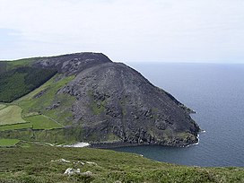
 Bradda Hill from the north after a gorse fire | |
| Highest point | |
| Elevation | 233 m (764 ft) |
| Prominence | c. 205 m |
| Listing | Marilyn |
| Geography | |
| Location | Isle of Man |
| OS grid | SC193711 |
| Topo map | OS Landranger 95 |
The path to the summit from Bradda West is part of the Raad ny Foillan, the Isle of Man Coast long distance footpath. Cliffs drop from the summit down to the sea. It shelters Fleshwick Bay from the west. A gorse fire in October 2003 took two days to control, five days to die, and scarred Bradda Hill and other headlands around Fleshwick.

References
- Isle of Man Guide story about the fire
На других языках
- [en] Bradda Hill
[fr] Bradda (colline)
La colline de Bradda (Gob Carn Vradda en mannois) est un promontoire rocheux situé près de Port Erin (sheading de Rushen), dans le sud-ouest de l'île de Man. Le sentier qui passe par son sommet fait partie du Raad ny Follian, le long sentier côtier de l'île de Man. La forme de la colline est particulière ; des falaises abruptes tombent depuis son sommet jusque dans la mer. Sur son sommet le plus proche de la mer se dresse une tour connue sous le nom de tour de Milner.Текст в блоке "Читать" взят с сайта "Википедия" и доступен по лицензии Creative Commons Attribution-ShareAlike; в отдельных случаях могут действовать дополнительные условия.
Другой контент может иметь иную лицензию. Перед использованием материалов сайта WikiSort.org внимательно изучите правила лицензирования конкретных элементов наполнения сайта.
Другой контент может иметь иную лицензию. Перед использованием материалов сайта WikiSort.org внимательно изучите правила лицензирования конкретных элементов наполнения сайта.
2019-2025
WikiSort.org - проект по пересортировке и дополнению контента Википедии
WikiSort.org - проект по пересортировке и дополнению контента Википедии