geo.wikisort.org - Mountains
Bottleneck Peak is a natural monolith located on the eastern side of Sids Mountain in the Utah San Rafael Swell wilderness area.[3] It is situated 2.1 miles (3.4 km) northwest of Window Blind Peak. Precipitation runoff from this feature drains north into the San Rafael River.
| Bottleneck Peak | |
|---|---|
 | |
| Highest point | |
| Elevation | 6,235 ft (1,900 m)[1] |
| Prominence | 455 ft (139 m)[1] |
| Parent peak | Point 6403[1] |
| Isolation | 0.65 mi (1.05 km)[1] |
| Coordinates | 39°04′06″N 110°40′51″W[1] |
| Geography | |
 Bottleneck Peak Location in Utah  Bottleneck Peak Bottleneck Peak (the United States) | |
| Location | Emery County, Utah, U.S. |
| Parent range | San Rafael Swell Colorado Plateau |
| Topo map | USGS Bottleneck Peak |
| Geology | |
| Type of rock | sandstone |
| Climbing | |
| First ascent | June 23, 1973 by Jim Langdon[2] |
| Easiest route | class 5.11- climbing[1] |
Gallery
 Bottleneck Peak and San Rafael River
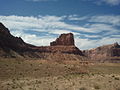


References
- "Bottleneck Peak - 6,235' UT". listsofjohn.com. Retrieved 2020-11-20.
- "First Ascent Timeline". DesertTowersBook.
- "Bottleneck Peak". Geographic Names Information System. United States Geological Survey. Retrieved 2020-11-20.
External links
- Weather forecast: Bottleneck Peak
- Bottleneck Peak rock climbing: Mountainproject.com
This article about a location in Utah is a stub. You can help Wikipedia by expanding it. |
На других языках
- [en] Bottleneck Peak
[fr] Pic Bottleneck
Le pic Bottleneck, en anglais Bottleneck Peak (littéralement, « pic du Goulot »), est un monolithe naturel, situé au nord-est de Sids Mountain dans le San Rafael Swell en Utah aux États-Unis. Il culmine à 1 952 mètres d'altitude.Текст в блоке "Читать" взят с сайта "Википедия" и доступен по лицензии Creative Commons Attribution-ShareAlike; в отдельных случаях могут действовать дополнительные условия.
Другой контент может иметь иную лицензию. Перед использованием материалов сайта WikiSort.org внимательно изучите правила лицензирования конкретных элементов наполнения сайта.
Другой контент может иметь иную лицензию. Перед использованием материалов сайта WikiSort.org внимательно изучите правила лицензирования конкретных элементов наполнения сайта.
2019-2026
WikiSort.org - проект по пересортировке и дополнению контента Википедии
WikiSort.org - проект по пересортировке и дополнению контента Википедии