geo.wikisort.org - Mountains
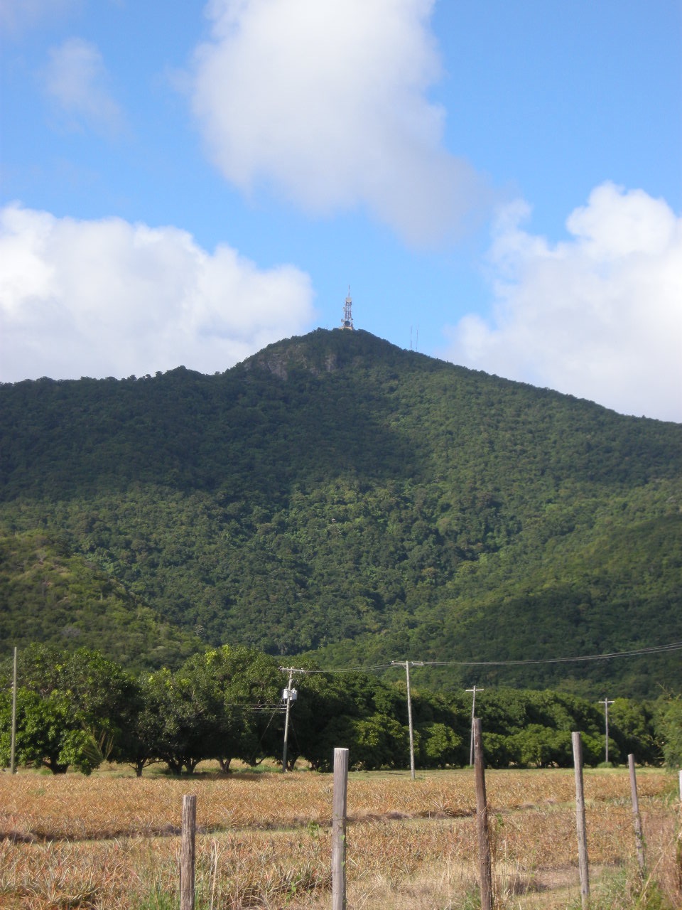
Boggy Peak, formerly named Mount Obama till 2016 (Reverted to Boggy Peak in 2016), is the highest point of the Shekerley Mountains on the island of Antigua. It lies in the southwest region of the island, and rises to a height of 402 metres (1,319 ft).[2][3]
| Boggy Peak | |
|---|---|
 | |
| Highest point | |
| Elevation | 402 m (1,319 ft)[1] |
| Prominence | 402 m (1,319 ft)[2] |
| Listing | Antigua's highest point |
| Coordinates | 17°02′31″N 61°51′04″W[2] |
| Geography | |
 Boggy Peak Antigua and Barbuda | |
| Parent range | Shekerley Mountains |
Enumeration District | |
| Country | Antigua and Barbuda |
| Island | Antigua |
| Parish | Saint Mary |
| Elevation | 402 m (1,319 ft) |
| Population (2001) | |
| • Total | 147 |
| Time zone | UTC-4 (AST) |
| Enumeration District Number | 82700 |
History
The area has significant cultural heritage as it was used during slavery times for sugarcane plantations. The name originated from slave masters telling stories about the dangers of the Boogie Man who took spirits and lived up in the mountains. This was to discourage slaves from escaping and running into the mountains. Runaways were able to make their own settlements in the mountains and actually live out their lives apart from enslavement.[citation needed]
On August 4, 2009, the peak was renamed Mount Obama by then-Prime Minister Baldwin Spencer, after United States president Barack Obama.[4] The original name was restored on June 21, 2016.[citation needed]
References
- "Boggy Peak" on summitpost.org Retrieved 2011-09-29.
- "Boggy Peak" on Peakbagger Retrieved 2011-09-29.
- "NGA GEOnet Names Server". National Geospatial-Intelligence Agency. 2008-07-07. Archived from the original on 2003-10-08. Retrieved 2008-07-22.
- "Antigua's highest peak renamed 'Mount Obama'". The Mercury News. 4 August 2009. Retrieved 16 March 2022.
This Antigua and Barbuda location article is a stub. You can help Wikipedia by expanding it. |
На других языках
[de] Boggy Peak
Boggy Peak (2009 bis 2016: Mount Obama) ist der Rest eines Vulkankraters in den Shekerley Mountains und gleichzeitig der höchste Punkt des karibischen Inselstaates Antigua und Barbuda mit 402 Metern. Er liegt im Südwesten der Insel Antigua. Eine Besteigung des Gipfels ist nicht möglich, da die obere Region des Boggy Peak eine Sperrzone für eine Telekommunikationsstation ist. Vom Gipfel aus ist ein Blick auf die umliegenden Inseln Montserrat und Guadeloupe möglich.[1]- [en] Boggy Peak
[fr] Mont Obama
Le mont Obama, anciennement connu sous le nom de Boggy Peak, est une montagne d'Antigua-et-Barbuda, le point culminant du pays. Il se situe à une altitude de 402 mètres dans la paroisse de Saint-Mary sur l'île d'Antigua.[ru] Холм Богги
Холм Богги (англ. Boggy Peak), с 2009 по 2016 год[2] был известен как гора Обама (англ. Mount Obama) — высшая точка государства Антигуа и Барбуда, находится в юго-западной части острова Антигуа. С вершины открывается вид на соседние острова Монтсеррат и ГваделупаДругой контент может иметь иную лицензию. Перед использованием материалов сайта WikiSort.org внимательно изучите правила лицензирования конкретных элементов наполнения сайта.
WikiSort.org - проект по пересортировке и дополнению контента Википедии