geo.wikisort.org - Mountains
Baring Mountain (or Mount Baring), is a peak in the central part of the Cascade Range of Washington, United States. It lies about 2 metres (0.0020 km) northeast of the Skykomish River and US Highway 2, at the western edge of the Cascades in the Mount Baker-Snoqualmie National Forest. It is about 6 miles (9.7 km) east of Mount Index and Barclay Lake at its base is accessible via Forest Road 6024 and a 2.2-mile (3.5 km) hike.[4]
| Baring Mountain | |
|---|---|
 Baring Mountain as seen from Barclay Lake | |
| Highest point | |
| Elevation | 6,127 ft (1,868 m) NAVD 88[1] |
| Prominence | 2,444 ft (745 m)[2] |
| Parent peak | Gunn Peak[3] |
| Coordinates | 47°46′45″N 121°26′09″W[1] |
| Geography | |
 Baring Mountain King County / Snohomish County, Washington, U.S.  Baring Mountain Baring Mountain (the United States) | |
| Parent range | Cascade Range |
| Climbing | |
| First ascent | July 28, 1897 by John Charlton, Albert H. Sylvester (first recorded ascent) |
| Easiest route | Hike/scramble |
Baring Mountain was previously known as Mount Index before being renamed in 1917. The peak currently named Mount Index was known as West Index Mountain until that time.[5]
Like Mount Index, Baring Mountain is a dramatic peak, because of its steep rise above low footings, the Skykomish River is at an elevation of only 760 feet (230 m), and particularly because of its large, sheer Northeast Face, which drops about 750 m (2,460 ft) in only 250 m (820 ft) and drops another 1,250 ft (380 m) at a lower angle to Barclay Lake.
The first recorded ascent of Baring Mountain was on July 28, 1897 by John Charlton and Albert H. Sylvester. However given the nontechnical nature of the easiest ascent route a much earlier Native American ascent is possible. The standard route on the mountain is the Northwest Ridge Route, involving hiking (off-trail, some of it through brush) and a small amount of scrambling at the top.
The northeast aspect of the peak is home to several routes of great length and technical difficulty (up to Grade VI, 5.12b).[6] The northeast face was first climbed on July 13, 1960 by Ed Cooper and Don Gordon Claunch.[7]
The first BASE jump off Baring Mountain was done by Todd Higley and Josh Whipple, in August 2001. Michael McMurtrey, of Seattle, was the first to jump from Baring using a wingsuit, in June 2004.[citation needed]
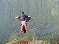 BASE Wingsuit Picture: First BASE wingsuit jumps off Baring Mountain (June, 2004)
 BASE Wingsuit Picture: First BASE wingsuit jumps off Baring Mountain (June, 2004)
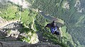 BASE Wingsuit Picture: Recent BASE wingsuit jump off Baring Mountain (September, 2010)


References
- "Baring". NGS data sheet. U.S. National Geodetic Survey. Retrieved 2011-06-07.
- "Baring Mountain, Washington". Peakbagger.com. Retrieved 2011-06-07.
- "Baring Mountain". Bivouac.com. Retrieved 2021-10-20.
- McQuaide, Mike (2005). Day hike! central Cascades. Sasquatch Books. ISBN 978-1-57061-412-5.
- Carlson, Warren (2009). Upper Skykomish Valley. Images of America. Charleston, SC: Arcadia Pub.
- Beckey, Fred (1987). Cascade Alpine Guide: Stevens Pass to Rainy Pass (2nd ed.). Seattle, Wash: The Mountaineers.
- Majors, Harry M. (1975). Exploring Washington. Van Winkle Publishing Co. p. 88. ISBN 978-0-918664-00-6.
External links
- "Baring Mountain". Geographic Names Information System. United States Geological Survey. Retrieved 2011-06-07.
- "Washington State Peaks with 2000 feet of Prominence". Peakbagger.com.
- "Baring Mountain". Bivouac.com.
- "Mount Baring". SummitPost.org. Retrieved 2011-06-07.
This King County, Washington state location article is a stub. You can help Wikipedia by expanding it. |
This Snohomish County, Washington state location article is a stub. You can help Wikipedia by expanding it. |
На других языках
[de] Mount Baring
Mount Baring, oder Baring Mountain, ist ein Berg in der Kaskadenkette im US-Bundesstaat Washington. Er liegt etwa drei Kilometer nordöstlich des Skykomish River, welcher bei Everett in den Puget Sound mündet. Das Gebiet um Mount Baring ist Teil des Mount Baker-Snoqualmie National Forests.- [en] Baring Mountain
Другой контент может иметь иную лицензию. Перед использованием материалов сайта WikiSort.org внимательно изучите правила лицензирования конкретных элементов наполнения сайта.
WikiSort.org - проект по пересортировке и дополнению контента Википедии