geo.wikisort.org - Mountains
The Badener Höhe is a mountain in the Northern Black Forest in the German state of Baden-Württemberg. It lies within the borough of Baden-Baden and municipality of Forbach. With a height of 1,002.5 m above sea level (NHN),[1] it is the highest point in the borough of Baden-Baden.
| Badener Höhe | |
|---|---|
 The Friedrichsturm on the Badener Höhe | |
| Highest point | |
| Elevation | 1,002.5 m above sea level (NHN) (3,289 ft) [1] |
| Listing | Highest point in Baden-Baden, Friedrichsturm (observation tower) |
| Coordinates | 48°40′7″N 8°16′31″E |
| Geography | |
 Badener Höhe Baden-Württemberg, Germany | |
| Parent range | Black Forest |
Location
The mountain rises above the hamlet of Herrenwies near the Schwarzenbach Reservoir. Its western and southern region is part of the Black Forest National Park.

Observation tower and views
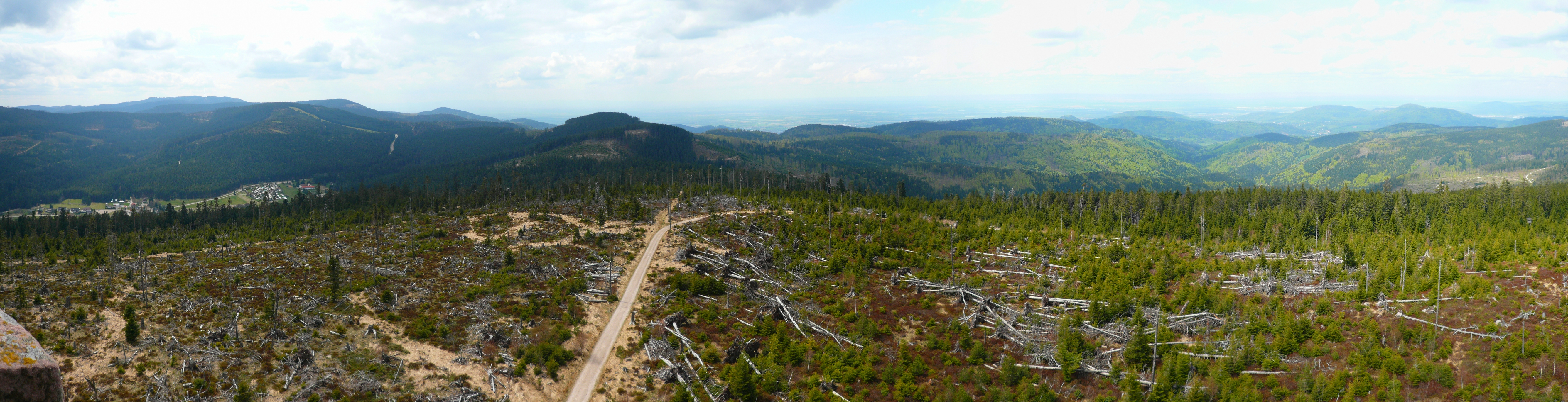
On the mountaintop, besides a refuge hut, is the 30-metre-high Frederick Tower (Friedrichsturm) built in 1890 by Anton Klein from red sandstone and inaugurated on 5 October 1891 by Grand Duke Frederick I of Baden.[2] The lookout tower is a highly visible cultural monument.[3] From here one can see far over the northern Black Forest, inter alia to Herrenwies, the nearby mountains of Mehliskopf and Hornisgrinde. To the north, on a very clear day, the Großer Feldberg, the Taunus hills and the Melibokus in the Odenwald Forest may be seen. To the north-northwest is the Palatinate Forest and, in good weather, even the Donnersberg may be seen. To the west, in France, rise the Vosges. In extremely good visibility some summits of the Swiss Alps may be visible to the far south-southeast. The panoramic view extends to the east to Swabian Jura. The tower was built in 1884 on the establishment of the Baden-Baden branch of Black Forest Club. In 2002, the tower had to be closed for safety reasons. Thanks to a fundraiser, the necessary restoration works were carried out quickly and the tower was re-opened on 19 June 2003.
Tourism
The Badener Höhe is now a popular hiking and excursion destination that is well linked to many hiking trails (such as the West Way or Westweg). The forest on the summit of the Badener Höhe fell victim to several storms, including Hurricane Lothar.
References
- Map services of the Federal Agency for Nature Conservation
- Badener Höhe Observation Tower – databank of geo-touristic objects at the Landesamt für Geologie, Rohstoffe und Bergbau, retrieved 6 April 2015
- Friedrichsturm (Badener Höhe) Archived 2015-02-28 at the Wayback Machine on the website of the town of Baden-Baden.
| Authority control |
|
|---|
На других языках
[de] Badener Höhe
Die Badener Höhe ist ein Berg im Nordschwarzwald auf den Gemarkungen von Baden-Baden und Forbach. Mit 1002,2 m ü. NHN[1] bildet sie den höchsten Punkt des Baden-Badener Stadtgebiets. Der Berg liegt oberhalb des Forbacher Ortsteils Herrenwies nahe der Schwarzenbachtalsperre. Sein westlicher und südlicher Bereich gehört zum Nationalpark Schwarzwald. Die Badener Höhe ist ein beliebtes Wander- und Ausflugsziel, das über viele Wanderwege (wie beispielsweise den Westweg) angebunden ist. Der Wald auf dem Gipfel der Badener Höhe ist mehreren Stürmen, darunter dem Orkan Lothar, weitgehend zum Opfer gefallen.- [en] Badener Höhe
Другой контент может иметь иную лицензию. Перед использованием материалов сайта WikiSort.org внимательно изучите правила лицензирования конкретных элементов наполнения сайта.
WikiSort.org - проект по пересортировке и дополнению контента Википедии