geo.wikisort.org - Mountains
The Twin Peaks are a set of mountain high points located on the Alpine Ridge within the Wasatch Range in Utah, on the border between Salt Lake and Utah County. They are usually referred to as the American Fork Twin Peaks, to distinguish them from the nearby Broads Fork Twin Peaks and Avenues Twin Peaks. Consisting of several sub-peaks, only one has the prominence to be considered a true summit. The summit has an elevation of 11,461 feet (3,493 m),[1] making it the highest point in Salt Lake County. The peak is also the most prominent in Salt Lake County, and one of the most prominent in the Wasatch Range.
| Twin Peaks | |
|---|---|
| American Fork Twin Peaks | |
 Northeast aspect | |
| Highest point | |
| Elevation | 11,461 ft (3,493 m)[1] |
| Coordinates | 40.5518953°N 111.6565908°W[1] |
| Geography | |
 Twin Peaks Location in Utah  Twin Peaks Twin Peaks (the United States) | |
| Country | United States of America |
| State | Utah |
| County | Salt Lake and Utah |
| Parent range | Wasatch Range |
| Topo map | Dromedary Peak |
Gallery
 American Fork Twin Peaks
 American Fork Twin Peaks
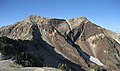 American Fork Twin Peaks


References
- "Twin Peaks". Geographic Names Information System. United States Geological Survey, United States Department of the Interior. Retrieved February 17, 2022.
Текст в блоке "Читать" взят с сайта "Википедия" и доступен по лицензии Creative Commons Attribution-ShareAlike; в отдельных случаях могут действовать дополнительные условия.
Другой контент может иметь иную лицензию. Перед использованием материалов сайта WikiSort.org внимательно изучите правила лицензирования конкретных элементов наполнения сайта.
Другой контент может иметь иную лицензию. Перед использованием материалов сайта WikiSort.org внимательно изучите правила лицензирования конкретных элементов наполнения сайта.
2019-2026
WikiSort.org - проект по пересортировке и дополнению контента Википедии
WikiSort.org - проект по пересортировке и дополнению контента Википедии