geo.wikisort.org - Mountains
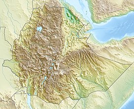
Amba Aradam is a table mountain in northern Ethiopia. Located in the Debub Misraqawi (Southeastern) Zone of the Tigray Region, between Mek'ele and Addis Abeba, it has a latitude and longitude of 13°20′N 39°31′E and an elevation of 2,756 metres (9,042 ft).
| Amba Aradam | |
|---|---|
| Highest point | |
| Elevation | 2,756 m (9,042 ft) |
| Coordinates | 13°20′N 39°31′E |
| Geography | |
| Location | Debub Misraqawi Zone, Tigray Region, Ethiopia |
The name in Tigrinya is Imba Aradom, but international usage in geology (Amba Aradam Formation) and history (battles in the 1930s) have coined the name Amba Aradam.
Geology

The outcropping bedrock consists of Jurassic, sub-horizontally layered or slightly inclined, marine varicoloured marls and marly clays with interbedded limestones, sandstones and gypsum layers, that are part of the Agula Shales Formation.[1] These are unconformably overlain by Cretaceous continental conglomerates, sandstones and laterite levels, belonging to the Amba Aradam Formation,[2] which is obviously named after the mountain. The unconformity is due to a planation episode which followed the pre-Cretaceous marine regression.[3] Dolerite sills and laccolites of Oligocene age[4] are interlayered within the Agula Shales. Small dolerite necks are exposed on the westernmost edge of the upper escarpment and west of the Amba Aradam summit.[5]

Vegetation
The present-day spontaneous vegetation is dominated by Juniperus procera, Eucalyptus camaldulensis and Podocarpus gracilior, although farming and grazing have reduced it to a sparse shrub cover, except for limited areas around churches where the holy character of the places allows their preservation.[5]
Settlements
Human settlements are scattered around the main relief, being usually located on the most favourable topographic situations, such as flat surfaces and foot slopes, where colluvial deposits allow subsistence farming.[5] Major town on the foot of the mountain is Hintalo, which used to be capital of Tigray in the 19th century, after which large parts of the town were abandoned.[6] Ruins of the abandoned quarters were observed in 1868 and are still present nowadays.
History
The mount is famous for the Battle of Enderta that the Italians fought in order to capture Amba Aradam on 15 February 1936, and for the massacre three years later, as an action against the Arbegnoch, or Ethiopian partisans.
Between 9–11 April 1939, a group of Arbegnoch, led by Abebe Aregai, had taken refuge in the Amezena Washa (Cavern of the Rebels), which was in Amba Aradam. The party included members of the Arbegnoch, but also their relatives, wounded, and other refugee non-combatants.
On 9 April 1939, the chemical platoon of the Granatieri di Savoia Division attacked the Arbegnoch using bombs with poison gas, killing most of those inside. Only fifteen persons succeeded in escaping from the cave. Those who continued the resistance inside the cave were killed with flamethrowers. The extent of the cave made it difficult to explore for the remaining members of the resistance who were still within, so the Italian military command gave the order to seal it with explosives:[7]
Si prevede che fetore cadaveri et carogne impediscano portare at termine esplorazione caverna che in questo sarà ostruita facendo brillare mine
— Telegramma del Governo Generale
We foresee that the stench of corpses and carrions will prevent us to carry out the exploration of the cave which will, for this reason, be obstructed with explosive mines
— Telegram form the General Governament
References
- Levitte, D (1970). The geology of Mekele. Report on the geology of the central part of sheet ND 37-11. Addis Ababa: Geological Survey of Ethiopia.
- Shumburo, M. (1968). The Amba Aradam formation (formerly the Upper Sandstone). Mobil Petroleum Ethiopia Inc.
- Coltorti, M.; Dramis, F.; Ollier, C. (2007). "Planation surfaces in Northern Ethiopia". Geomorphology. 89 (3–4): 287–296. doi:10.1016/j.geomorph.2006.12.007.
- Justin-Visentin, E. (1974). "Petrografia, chimismo e petrogenesi dei corpi subvulcanici di Macallè (Tigrai Etiopia)". Memorie dell'Istituto di Geologia e Mineralogia, Universita di Padova. 31: 1–33.
- Coltorti, M.; Pieruccini, P.; Ogbagabriel Berakhi; Dramis, F.; Asfawossen Asrat (2009). "The Geomorphological Map of Mt. Amba Aradam Southern Slope (Tigray, Ethiopia)". Journal of Maps. 5 (1): 56–65. doi:10.4113/jom.2009.1043. S2CID 129046585.
- Markham, C.; Prideaux, W. (1869). A history of the Abyssinian expedition. Macmillan.
- (in Italian) Paolo Rumiz, "Etiopia: quella strage fascista mai raccontata"La Repubblica, 22 Maggio 2006.
На других языках
- [en] Amba Aradam
[it] Amba Aradam
L'Amba Aradam (amarico: አምባ አረደም, Āmiba Āredemi) è un altopiano montuoso (amba) situato a sud della città di Macallè e a circa 500 km a nord della città di Addis Abeba in Etiopia, nel sud-est della regione dei Tigrè.[ru] Амба-Арадом
Амба-Арадом[1], Амба-Арадам[1] (амх. አምባ አራዶም) — гора в северной части Эфиопии. Расположена в регионе Тыграй, между городами Мэкэле и Аддис-Абеба. Высота горы достигает до 2756 метров. Гора знаменита битвой которая происходила 15 февраля 1936 года, итальянцы пытались захватить Амба-Арадом.[2]Другой контент может иметь иную лицензию. Перед использованием материалов сайта WikiSort.org внимательно изучите правила лицензирования конкретных элементов наполнения сайта.
WikiSort.org - проект по пересортировке и дополнению контента Википедии
