geo.wikisort.org - Mountains
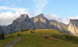
The Alvier (German pronunciation: [alˈfiːɐ̯] (![]() listen)) is a mountain in the Appenzell Alps, located halfway between Lake Walenstadt and the Rhine in the canton of St. Gallen. It is one of the main summits of the chain separating the valleys of the river Seez and the Rhine.
listen)) is a mountain in the Appenzell Alps, located halfway between Lake Walenstadt and the Rhine in the canton of St. Gallen. It is one of the main summits of the chain separating the valleys of the river Seez and the Rhine.
| Alvier | |
|---|---|
 | |
| Highest point | |
| Elevation | 2,343 m (7,687 ft) |
| Prominence | 243 m (797 ft)[1] |
| Parent peak | Gamsberg |
| Isolation | 2.59 km (1.61 mi) |
| Coordinates | 47°06′35.1″N 09°24′53.4″E |
| Geography | |
| Location | St. Gallen, Switzerland |
| Parent range | Appenzell Alps |
Although involving a long hike, the summit is easily accessible by trails from both sides.
References
- Swisstopo maps
На других языках
[de] Alvier (Berg)
Der Alvier (2343 m ü. M.) ist der namensgebende Gipfel der Alviergruppe im Kanton St. Gallen in der Schweiz, die erst beim etwas niedereren Gauschla (2310 m) endet.- [en] Alvier (mountain)
[fr] Alvier
L'Alvier est un sommet de 2 341 m d'altitude. Il est situé dans le canton suisse de Saint-Gall.Текст в блоке "Читать" взят с сайта "Википедия" и доступен по лицензии Creative Commons Attribution-ShareAlike; в отдельных случаях могут действовать дополнительные условия.
Другой контент может иметь иную лицензию. Перед использованием материалов сайта WikiSort.org внимательно изучите правила лицензирования конкретных элементов наполнения сайта.
Другой контент может иметь иную лицензию. Перед использованием материалов сайта WikiSort.org внимательно изучите правила лицензирования конкретных элементов наполнения сайта.
2019-2025
WikiSort.org - проект по пересортировке и дополнению контента Википедии
WikiSort.org - проект по пересортировке и дополнению контента Википедии
