geo.wikisort.org - Mountains
Allmannberget is a mountain in the municipality of Oppdal in Trøndelag county, Norway. The 1,342-metre (4,403 ft) tall mountain sits about 3 kilometres (1.9 mi) southeast of the village of Oppdal, easily seen from the European route E06 highway.

| Allmannberget | |
|---|---|
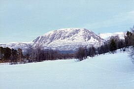 View of the mountain | |
| Highest point | |
| Elevation | 1,342 m (4,403 ft) |
| Coordinates | 62.5687°N 09.7114°E[1] |
| Geography | |
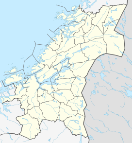 Allmannberget Location of the mountain  Allmannberget Allmannberget (Norway) | |
| Location | Trøndelag, Norway |
| Topo map | 1520 III Oppdal (summit) and 1520 II Innset (ascent) |
The easiest hiking route is from the east-north-east. Drive on the gravel toll road from the E6 highway partially up the Olmdalen valley, then walk approximately 2.5 kilometres (1.6 mi) to the summit. There is a communication tower on the top of the mountain.
Name
The first element is allmann which means "common/public property" (literally "for all men"), and the last element is the finite form of berg which means "rocky mountain".
References
- "Allmannberget, Oppdal (Trøndelag)" (in Norwegian). yr.no. Retrieved 2017-03-23.
This Trøndelag location article is a stub. You can help Wikipedia by expanding it. |
Другой контент может иметь иную лицензию. Перед использованием материалов сайта WikiSort.org внимательно изучите правила лицензирования конкретных элементов наполнения сайта.
WikiSort.org - проект по пересортировке и дополнению контента Википедии