geo.wikisort.org - Mountains
The Albera Massif (Catalan: Serra de l'Albera) (French: Massif des Albères) is a mountain range located in the south of Pyrénées-Orientales and the north of Catalonia, between France and Spain. It is the main easternmost prolongation of the Pyrenees. Its highest peak is the Puig Neulós, with an elevation of 1,256 metres.
| Albera Massif | |
|---|---|
 The northern side of the Albera Massif seen from Sant Genís de Fontanes | |
| Highest point | |
| Elevation | 1,256 m (4,121 ft) |
| Coordinates | 42°28′55″N 2°56′49″E |
| Geography | |
 Albera Massif Location in the Pre-Pyrenees area | |
| Location | Pyrénées-Orientales Empordà, Catalonia |
| Parent range | Foothills of the Pyrenees |
| Climbing | |
| First ascent | Unknown |
| Easiest route | From La Jonquera or Sureda |
Most of the southern side of the range is part of the Paratge Natural d'Interès Nacional de l'Albera natural reserve.[1] There are some ancient megaliths in the range.[2] The Col du Perthus marks the western boundary of the massif.
History
The Albera Range became the border between France and Spain following the Treaty of the Pyrenees, when Philip IV of Spain ceded a part of the Spanish kingdom to Louis XIV of France, dividing Northern Catalonia from Historical Catalonia.
Gallery
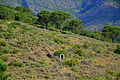 Albera Massif
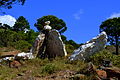 Albera Massif
 Albera Massif
 Albera Massif


See also
- Treaty of the Pyrenees
- Mountains of Catalonia
References
- Paratge Natural d'Interès Nacional de l'Albera. Col·lecció 1:25.000. Espais naturals protegits, Barcelona, Institut Cartogràfic de Catalunya, 1999
- Monuments megalítics de l'Albera
External links
- Paratge Natural d'Interès Nacional de l'Albera
- Requesens - Puig Neulós hiking route
- Manel Figuera i Abadal, 50 ascensions fàcils pel Pirineu català, Valls, Cossetània, 2008
- Centre de reproducció de tortugues de l'Albera
Authority control | |
|---|---|
| General |
|
| National libraries | |
This Province of Girona location article is a stub. You can help Wikipedia by expanding it. |
На других языках
[de] Serra de l’Albera
Die Serra de l’Albera (Französisch: Massif des Albères) ist ein Gebirgszug im Norden von Katalonien, im Grenzgebiet zwischen Frankreich und Spanien. Es ist die östlichste Ausdehnung der Pyrenäen und erstreckt sich bis zum Mittelmeer. Der höchste Berg der Gebirgskette ist der Puig Neulós (Französisch: Pic du Néoulous) mit einer Höhe von 1256 m. Weitere bekannte Berge sind der Puig dels Pastors (1167 m), der Puig dels Quatre Termes (1156 m) und der Pico de Sallafort (992 m).- [en] Albera Massif
[es] Sierra de la Albera
La sierra de la Albera, o también Macizo de la Albera, (en francés massif des Albères, en catalán : serra de l'Albera) es un macizo montañoso situado en la parte más oriental de la Cordillera Pirenaica, desde el Col du Perthus hasta el mar Mediterráneo.[fr] Massif des Albères
Le massif des Albères (en catalan : serra de l'Albera ou massís de l'Albera, en espagnol : sierra de la Albera) est un massif de montagnes qui constitue la partie la plus orientale de la chaîne pyrénéenne.[it] Monti Albères
I Monti Albères (francese: Massif des Albères, catalano: Serra de l'Albera) sono la catena montuosa più orientale dei Pirenei al confine fra la Francia e la Spagna. La cima più alta è il Pic de Neulos (1.256 m).Другой контент может иметь иную лицензию. Перед использованием материалов сайта WikiSort.org внимательно изучите правила лицензирования конкретных элементов наполнения сайта.
WikiSort.org - проект по пересортировке и дополнению контента Википедии