geo.wikisort.org - Mountains
Žljeb (Serbian Cyrillic: Жљеб; Albanian: Zhleb) is a mountain located between western Kosovo[a] and the Rožaje Municipality of eastern Montenegro. It is a part of the Accursed Mountains (or Prokletije/Bjëshket e Nemurë), located between the mountains of Hajla and Mokna. The majority of the land within the mountain belongs to Kosovo, while a minority of it belongs to Montenegro.. The White Drin (or Bijeli Drim) river originates from within the mountain.
| Žljeb | |
|---|---|
 Zhlebi (2365m) | |
| Highest point | |
| Elevation | 2,382 m (7,815 ft) |
| Coordinates | 42°46′12″N 20°15′12″E |
| Geography | |
 Žljeb Location in Montenegro and in Kosovo 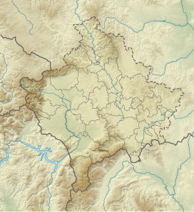 Žljeb Žljeb (Kosovo) | |
| Location | Montenegro, Kosovo [a] |
| Parent range | Prokletije |
The Žljeb mountain also forms part of the eastern side of the Rugova Canyon. It also has two high and impressive peaks: the higher is called Rusulija (Albanian: Ruselia/Rusulisë) and is 2,382 m (7,815 ft) high, while the lower is simply called Zhlebit, at 2,365 m (7,759 ft). Rusulija's slopes are covered with rich forests and near the summit there are several meadows. The road from the city of Rožaje to Pejë (or Peć) is located within the foothills of the mountains, and also contains 2 or 3 villages within that road. It also contains the border crossings between Montenegro and Kosovo, the Montenegrin one is called "Kula/Kulla".
Notes and references
Notes:
| a. | ^ The political status of Kosovo is disputed. Having unilaterally declared independence from Serbia in 2008, the Republic of Kosovo is formally recognised as an independent state by 97 UN member states (with another 15 states recognising it at some point but then withdrawing their recognition), while Serbia continues to claim Kosovo as a part of its own sovereign territory. |
References:
This Kosovo location article is a stub. You can help Wikipedia by expanding it. |
This Montenegro location article is a stub. You can help Wikipedia by expanding it. |
Другой контент может иметь иную лицензию. Перед использованием материалов сайта WikiSort.org внимательно изучите правила лицензирования конкретных элементов наполнения сайта.
WikiSort.org - проект по пересортировке и дополнению контента Википедии