geo.wikisort.org - Bergen
Der Puigmal bzw. Puigmal d’Er ist ein Berg in den Ostpyrenäen, an der Grenze zwischen Frankreich und Spanien. Der Puigmal ist kein auffälliger oder besonders charakteristischer Berg. Dennoch führt die beliebteste Gipfeltour aus dem Vall de Núria auf den Puigmal, dem dort höchsten Berg, der dem Wanderer eine traumhafte Aussicht bietet.
| Puigmal | ||
|---|---|---|

Der Puigmal von Fontalba aus gesehen | ||
| Höhe | 2913 msnm | |
| Lage | Grenze Okzitanien (Frankreich) / Katalonien (Spanien) | |
| Gebirge | Pyrenäen | |
| Koordinaten | 42° 23′ 0″ N, 2° 7′ 0″ O | |
| ||

Routen
Von französischer Seite sowie von spanischer Seite führen mittelschwere Wander- und Skitouren auf den Gipfel:
- Sanktuarium im Vall de Núria (1.967 m) – Puigmal: 2,5 Gehstunden
- Fontalba – Puigmal
- Les Planes – Puigmal
Auf französischer Seite befindet sich das Skigebiet Cerdagne Puigmal 2900.
Literatur
- Roger Büdeler: Pyrenäen 3 – Spanische Ostpyrenäen: Val d’Aran bis Núria. Bergverlag Rother, München 2004, ISBN 3-7633-4309-1.
- F. Salvador, R. Ma. Asencio: Vall de Núria – Plànol d’excursions. Ferrocarrils de la Generalitat de Catalunya, Ripoll 1991 Ausgabe 2001.
- Puigmal, Vall de Núria, Ulldeter - Mapa i guia excursionista i turística; Editorial Alpina, SL: ISBN 84-8090-196-9; Societat Gestora d'Informació Territorial, GEOESTEL, SA: ISBN 84-9578-846-2.
Weitere Bilder
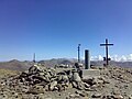 Der Puigmal-Gipfel
 Der Puigmal von Osten gesehen
 Der Puigmal von Guils de Cerdaña gesehen


Weblinks
Commons: Puigmal – Sammlung von Bildern, Videos und Audiodateien
На других языках
- [de] Puigmal
[en] Puigmal
The Peak of Puigmal (Catalan pronunciation: [ˌpudʒˈmal]), also called Puigmal d'Er, is a mountain in the Pyrenees, in the Spanish-French border, within the limits of the municipality of Queralbs and the commune of Err. Its summit is 2,909.6 metres (9,546 ft) above sea level, one of the highest peaks in the eastern Pyrenees.[1] Puigmal d'Err is near the west end of a fine ridge over 2500m high for 16 km. The west half is composed of friable metasediments (schists) which break down to form smooth slopes, and so give easy walking. The east half is of tougher gneiss and forms spiky alpine scenery with sharp crests and some difficult places. Several excellent circuits can be made from Nuria. The plateau summit of Puigmal d'Err is split for several hundred metres by a bold scarp, in places over 20 metres high, with the eastern half having slipped bodily towards Nuria. This is clearly seen on GoogleEarth. Several other crests in this range are likewise split.[2][es] Puigmal
El Puigmal (en francés Puymal) llamado también Puigmal de Er (en catalán Puigmal d'Er, en francés Puymal d'Err) en la Alta Cerdaña, es la segunda montaña más alta de la provincia de Gerona (2914 msnm), situada en la frontera de España con Francia.[fr] Puigmal
Le Puigmal (prononcé Poutchmal) ou Puigmal d'Err est un sommet des Pyrénées culminant à 2 910 m. Il est situé à la frontière franco-espagnole, sur la commune d'Err dans les Pyrénées-Orientales, et celle de Queralbs dans la province de Gérone.[ru] Пучмаль
Пучма́ль[2][1] (кат. Puigmal) — гора высотой 2909 м над уровнем моря (по другим данным — 2913 м[2]) в восточных Пиренеях, на границе Франции и Испании[2], к юго-востоку от горы Карлит[en] (2921 м) и к юго-западу от горы Канигу (2784 м)[1]. Относительная высота — 1331 м. Расположена на границе испанского муниципалитета Керальбс и французской коммуны Эрр[en] департамента Восточные Пиренеи.Текст в блоке "Читать" взят с сайта "Википедия" и доступен по лицензии Creative Commons Attribution-ShareAlike; в отдельных случаях могут действовать дополнительные условия.
Другой контент может иметь иную лицензию. Перед использованием материалов сайта WikiSort.org внимательно изучите правила лицензирования конкретных элементов наполнения сайта.
Другой контент может иметь иную лицензию. Перед использованием материалов сайта WikiSort.org внимательно изучите правила лицензирования конкретных элементов наполнения сайта.
2019-2026
WikiSort.org - проект по пересортировке и дополнению контента Википедии
WikiSort.org - проект по пересортировке и дополнению контента Википедии