geo.wikisort.org - Bergen
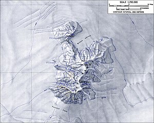
Mount Kosciusko ist ein markanter und 2909 m hoher erloschener Schildvulkan im westantarktischen Marie-Byrd-Land. Er nimmt den zentralen Teil der Ames Range ein.
| Mount Kosciusko | ||
|---|---|---|

Topografische Karte der Ames Range mit Mount Kosciusko (Maßstab 1:250.000) | ||
| Höhe | 2909 m | |
| Lage | Marie-Byrd-Land | |
| Gebirge | Ames Range | |
| Koordinaten | 75° 43′ 0″ S, 132° 13′ 0″ W | |
|
| ||
| Typ | Schildvulkan, erloschen | |
| Normalweg | Hochtour (vergletschert) | |
Der United States Geological Survey kartierte ihn anhand eigener Vermessungen und Luftaufnahmen der United States Navy aus den Jahren von 1959 bis 1965. Das Advisory Committee on Antarctic Names benannte ihn 1974 nach Captain Henry Marzy Kosciusko (1917–1997), Leiter der Aktivitäten der Unterstützungseinheiten der US Navy in Antarktika von 1965 bis 1967.
Weblinks
- Mount Kosciusko im Geographic Names Information System des United States Geological Survey (englisch)
- Mount Kosciusko auf geographic.org (englisch)
На других языках
- [de] Mount Kosciusko (Antarktika)
[en] Mount Kosciusko (Antarctica)
Mount Kosciusko is a mountain, rising to 2,910 metres (9,550 ft), that comprises the central portion of the Ames Range in Marie Byrd Land, Antarctica. It was mapped by the United States Geological Survey from surveys and U.S. Navy air photos, 1959–1965, and was named by the Advisory Committee on Antarctic Names for Captain Henry M. Kosciusko, U.S. Navy, Commander of the Antarctic Support Activities group, 1965–1967.[1][fr] Mont Kosciusko
Le mont Kosciusko est un volcan de l'Antarctique. Il est séparé du mont Kauffman par la vallée Brown et la crête Gardiner.Текст в блоке "Читать" взят с сайта "Википедия" и доступен по лицензии Creative Commons Attribution-ShareAlike; в отдельных случаях могут действовать дополнительные условия.
Другой контент может иметь иную лицензию. Перед использованием материалов сайта WikiSort.org внимательно изучите правила лицензирования конкретных элементов наполнения сайта.
Другой контент может иметь иную лицензию. Перед использованием материалов сайта WikiSort.org внимательно изучите правила лицензирования конкретных элементов наполнения сайта.
2019-2025
WikiSort.org - проект по пересортировке и дополнению контента Википедии
WikiSort.org - проект по пересортировке и дополнению контента Википедии
