geo.wikisort.org - Bergen
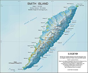
Mount Christi ist ein 1280 m hoher Berg auf Smith Island im Archipel der Südlichen Shetlandinseln. In der Imeon Range ragt er 5 km nordöstlich des Mount Pisgah im nordöstlichen Teil der Insel auf.
| Mount Christi | ||
|---|---|---|

Karte von Smith Island mit dem Mount Christi (rechts oben) | ||
| Höhe | 1280 m | |
| Lage | Smith Island, Südliche Shetlandinseln | |
| Gebirge | Imeon Range | |
| Koordinaten | 62° 54′ 37″ S, 62° 24′ 7″ W | |
|
| ||
| Normalweg | Hochtour (vergletschert) | |
Der britische Polarreisende Henry Foster benannte während seiner von 1828 bis 1831 dauernden Antarktisexpedition das Nordkap von Smith Island als Kap Christi. Da dieses jedoch bereits als Kap Smith benannt war, übertrug das UK Antarctic Place-Names Committee im Jahr 1953 Fosters Benennung aus Kontinuitätsgründen auf den hier beschriebenen Berg. Namensgeber ist der britische Mathematiker und Naturforscher Samuel Hunter Christie [sic!] (1784–1865), mit dem Foster 1826 ein Buch zum Erdmagnetismus veröffentlicht hatte.[1]
Weblinks
- Mount Christi im Geographic Names Information System des United States Geological Survey (englisch)
- Mount Christi auf geographic.org (englisch)
Einzelnachweise
- John Stewart: Antarctica – An Encyclopedia. Bd. 1, McFarland & Co., Jefferson und London 2011, ISBN 978-0-7864-3590-6, S. 320 (englisch).
На других языках
- [de] Mount Christi
[en] Mount Christi
Mount Christi is a mountain rising to 1,280 metres (4,200 ft) in the northern Imeon Range on Smith Island in the South Shetland Islands, Antarctica. The peak overlooks Kongur Glacier to the west-northwest, Saparevo Glacier to the north and Ritya Glacier to the southeast.Другой контент может иметь иную лицензию. Перед использованием материалов сайта WikiSort.org внимательно изучите правила лицензирования конкретных элементов наполнения сайта.
WikiSort.org - проект по пересортировке и дополнению контента Википедии
