geo.wikisort.org - Bergen
Der Kyrkja ist ein Berg in Norwegen und liegt in der Provinz Innlandet im Jotunheimen-Nationalpark in unmittelbarer Nähe der Wanderunterkunft Leirvassbu. Seine Höhe beträgt 2032 moh.
| Kyrkja | ||
|---|---|---|

Kyrkja | ||
| Höhe | 2032 moh. | |
| Lage | Provinz Innlandet, Norwegen | |
| Gebirge | Jotunheimen-Gebirge | |
| Koordinaten | 61° 32′ 34″ N, 8° 17′ 24″ O | |
| ||

Entstehung des Namens
Kyrkja bedeutet in die deutsche Sprache übersetzt Kirche. Der Name begründet sich vermutlich in der Silhouette dieses Berges, die an einen Kirchturm mit Kirchenschiff erinnert.
Route zum Gipfel
Die Normalroute führt über die Südflanke und ist im Gipfelaufbau etwas ausgesetzt.
Fotografien
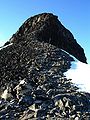 Blick über den Südgrat zum Gipfelaufbau
 Blick vom Gipfel
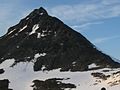 Blick aus Südwest


Weblinks
На других языках
- [de] Kyrkja
[en] Kyrkja
Kyrkja is a mountain in Lom Municipality in Innlandet county, Norway. The 2,032-metre (6,667 ft) tall mountain is located in the Jotunheimen mountains within Jotunheimen National Park. The mountain sits about 35 kilometres (22 mi) south of the village of Fossbergom and about 35 kilometres (22 mi) northeast of the village of Øvre Årdal. The mountain is surrounded by several other notable mountains including Urdadalstindene and Semelholstinden to the east; Kyrkjeoksli, Visbretinden, and Langvasshøi to the southeast; Høgvagltindene to the south; Stehøi and Stetinden to the west; and Tverrbottindene and Tverrbytthornet to the north.[1]Текст в блоке "Читать" взят с сайта "Википедия" и доступен по лицензии Creative Commons Attribution-ShareAlike; в отдельных случаях могут действовать дополнительные условия.
Другой контент может иметь иную лицензию. Перед использованием материалов сайта WikiSort.org внимательно изучите правила лицензирования конкретных элементов наполнения сайта.
Другой контент может иметь иную лицензию. Перед использованием материалов сайта WikiSort.org внимательно изучите правила лицензирования конкретных элементов наполнения сайта.
2019-2026
WikiSort.org - проект по пересортировке и дополнению контента Википедии
WikiSort.org - проект по пересортировке и дополнению контента Википедии