geo.wikisort.org - Bergen
Der Bray Head (irisch: Ceann Bhré) ist ein 241 m ASL hoher Berg in der irischen Grafschaft Wicklow im Osten Irlands. Er ist eine der Touristenattraktionen der Stadt Bray. An seinem östlichen Fuß liegt der erste in Europa versteckte Geocache „Europe's First“.[1]
| Bray Head | ||
|---|---|---|

Bray Head, 2007 | ||
| Höhe | 241 m ASL | |
| Lage | County Wicklow, Irland | |
| Koordinaten | 53° 11′ 26″ N, 6° 5′ 3″ W | |
| ||

Bilder
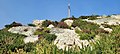 Blick auf die Bergspitze
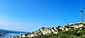 Bergspitze mit Panorama von Bray
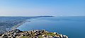 Blick von der Bergspitze auf Bray


Weblinks
Commons: Bray Head – Sammlung von Bildern, Videos und Audiodateien
Einzelnachweise
- geocaching.com: Europe's First Geocache
На других языках
- [de] Bray Head
[en] Bray Head
Bray Head (Irish: Ceann Bhré) is a 241 m (791 ft) hill and headland located in northern County Wicklow, Ireland, between the towns of Bray and Greystones. It forms part of the Wicklow Mountains and is a popular spot with hillwalkers. At the top of the head is a concrete cross which was placed there in 1950 during the holy year. Every Good Friday, hundreds of local people climb to the top of the head in a Good Friday procession marking the stations of the Cross as they go along, with the final station being held at the holy year cross.[1] The headland and adjacent lands were designated under a Special Amenity Area Order in March 2008.[2][es] Bray Head
Bray Head (en irlandés, Ceann Bhré) es una montaña localizada al norte del condado de Wicklow, Irlanda, entre las poblaciones de Bray y Greystones. Forma parte de los Montes Wicklow y es popular entre los senderistas. Su altitud máxima es de 243 metros.[fr] Bray Head
Bray Head (en irlandais : Ceann Bhré) est un sommet des montagnes de Wicklow culminant à 241 mètres d'altitude, en Irlande, au sud-sud-est de Bray et au nord de Greystones.[ru] Брей-Хед
Брей-Хэд — прибрежный холм высотой 241 метр, расположенный на севере графства Уиклоу, Ирландия, между городами Брей и Грейстоунс. Является частью хребта Уиклоу и популярным местом пеших прогулок. На вершине холма в юбилейном 1950-м году был установлен крест, к которому в Страстную пятницу совершается крестный ход. В прибрежных скалах проходит железная дорога, разработанная Изамбардом Брюнелем.Текст в блоке "Читать" взят с сайта "Википедия" и доступен по лицензии Creative Commons Attribution-ShareAlike; в отдельных случаях могут действовать дополнительные условия.
Другой контент может иметь иную лицензию. Перед использованием материалов сайта WikiSort.org внимательно изучите правила лицензирования конкретных элементов наполнения сайта.
Другой контент может иметь иную лицензию. Перед использованием материалов сайта WikiSort.org внимательно изучите правила лицензирования конкретных элементов наполнения сайта.
2019-2026
WikiSort.org - проект по пересортировке и дополнению контента Википедии
WikiSort.org - проект по пересортировке и дополнению контента Википедии