geo.wikisort.org - Isola
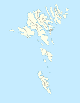
Sandoy è un'isola dell'arcipelago delle Isole Fær Øer, la più grande della regione di Sandoy, di superficie complessiva 111,3 km²; è situata a sud delle isole di Streymoy, Nólsoy ed Hestur, ed a nord di quella di Suðuroy e degli isolotti di Skúvoy, Stóra Dímun e Lítla Dímun.
| Sandoy | |
|---|---|
 | |
| Geografia fisica | |
| Localizzazione | Mare di Norvegia |
| Coordinate | 61°51′N 6°47′W |
| Arcipelago | Isole Fær Øer |
| Superficie | 111,3[1] km² |
| Altitudine massima | 479 m s.l.m. |
| Geografia politica | |
| Stato | |
| Nazione costitutiva | |
| Centro principale | Sandur |
| Demografia | |
| Abitanti | 1.245 (2016) |
| Densità | 12 ab./km² |
| Cartografia | |
 | |
| voci di isole della Danimarca presenti su Wikipedia | |
Il centro abitato più popolato è Sandur. Altri centri di rilievo sono Skálavík, Húsavík, Dalur, Skarvanes e Skopun. Sull'isola fra le cime di una certa rilevanza si annoverano Knúkur (369 m) e Tindur (479 m).
Vicino alla città di Skopun vi è un piccolo scoglio, il Trøllhøvdi, mentre nella principale città di Sandur vi è il lago Sandsvatn. Sull'isola vi sono gli attracchi di Sandur e Skopun, oltre a quello di Skúvoy sull'omonima isola.
Orografia
| Rilievo | Altezza |
|---|---|
| Tindur | 479 m |
| Skorarnar | 460 m |
| Endin (Trøðum) | 452 m |
| Pætursfjall | 447 m |
| Eiriksfjall | 412 m |
| Endin | 410 m |
| Kneysurin | 404 m |
| Vestfelli | 397 m |
| Stórafjall | 396 m |
| Vørðan | 373 m |
| Knúkur | 369 m |
| Fjallið | 362 m |
| Skúvoyarfjall | 354 m |
| Bøllufjall | 312 m |
| Gleðin | 271 m |
| Heiðafjall | 266 m |
| Nakkurin | 251 m |
| Skálhøvdi | 203 m |
| Salthøvdi | 139 m |
Note
- Faroe Islands in figures 2017 (PDF), su hagstova.fo, Hagstova Føroya. URL consultato il 21 novembre 2017 (archiviato dall'url originale il 5 febbraio 2018).
Altri progetti
 Wikimedia Commons contiene immagini o altri file su Sandoy
| Controllo di autorità | VIAF (EN) 1190149198246574940008 |
|---|
На других языках
[de] Sandoy
Sandoy [.mw-parser-output .IPA a{text-decoration:none}ˈsandɔi]/[ˈsandi] (dänisch Sandø, deutsche Bedeutung Sandinsel) ist die fünftgrößte Insel der Färöer. Die Insel hat 19 Gipfel, deren höchster der Tindur mit 479 m ist.[en] Sandoy
Sandoy ("Sand Island") is the first of the five southern islands that make up the Faroe chain, the fifth biggest of all the Faroe Islands,[2] an autonomous region of the Kingdom of Denmark. It also refers to the region that includes this island along with Skúvoy and Stóra Dímun. As of January 2020[update], the largest population centre on the island is the village of Sandur with a population of 532.[3] Other settlements include Skarvanes, Skopun, Skálavík, Húsavík and Dalur.[es] Sandoy
Sandoy (en danés: Sandø) es la quinta isla en extensión de las 18 que forman el archipiélago de las Islas Feroe (Dinamarca), situado en el Mar de Noruega.[fr] Sandoy
Sandoy, en danois Sandø, est une des îles de l'archipel des Féroé, la cinquième par la superficie. La ville la plus peuplée de l'île est Sandur, avec environ 600 habitants ; les autres villages sont Skarvanes, Skopun, Skálavík, Húsavík et Dalur.- [it] Sandoy
[ru] Сандой
Са́ндой[1][2] (фар. Sandoy), Са́ннё[3] (дат. Sandø) — один из островов Фарерского архипелага. На западе острова расположена большая колония кайр. На самом южном конце острова есть маяк.Текст в блоке "Читать" взят с сайта "Википедия" и доступен по лицензии Creative Commons Attribution-ShareAlike; в отдельных случаях могут действовать дополнительные условия.
Другой контент может иметь иную лицензию. Перед использованием материалов сайта WikiSort.org внимательно изучите правила лицензирования конкретных элементов наполнения сайта.
Другой контент может иметь иную лицензию. Перед использованием материалов сайта WikiSort.org внимательно изучите правила лицензирования конкретных элементов наполнения сайта.
2019-2025
WikiSort.org - проект по пересортировке и дополнению контента Википедии
WikiSort.org - проект по пересортировке и дополнению контента Википедии
