geo.wikisort.org - Isola
Long Island[2] è un'isola fluviale che si trova nel fiume Hawkesbury, circa 50 km a nord di Sydney, nel Nuovo Galles del Sud, in Australia. L'isola appartiene alla Local Government Area della Contea di Hornsby[3].
| Long Island | |
|---|---|
 | |
| Geografia fisica | |
| Localizzazione | Fiume Hawkesbury |
| Coordinate | 33°32′33″S 151°13′07″E |
| Superficie | 0,73[1] km² |
| Geografia politica | |
| Stato | |
| Stato federato | |
| Local government area | Contea di Hornsby |
| Cartografia | |
 Long Island | |
| voci di isole dell'Australia presenti su Wikipedia | |
È una delle isole del fiume Hawkesbury, assieme a Dangar, Spectacle, Milson, Peat e Lion Island.
Geografia
All'estremità orientale, Long Island è unita alla terraferma da una strada rialzata che si diparte verso sud, attraversa il Sandbrook Inlet[4] e la collega con il sobborgo di Brooklyn, e dal ponte della ferrovia che, diretto a nord, la collega con Cogra Point.
Long Island ha una forma allungata e un'area di 73 ettari; fa parte della riserva naturale del parco nazionale Ku-Ring-Gai Chase.[1]
Isole adiacenti
- Dangar Island, situata a est di Long Island, ha un'area di 29 ettari e una popolazione di 303 abitanti (censimento del 2016)[5].
- Milson Island, a nord-ovest di Long Island, al centro del fiume 33°30′47″S 151°10′48″E.
- Peat Island, piccola isola di circa 8 ettari, fa parte del sobborgo chiamato Mooney Mooney ed è collegata alla terraferma da un ponte.
- Spectacle Island, si trova a nord di Long Island, ha un'area di 36,4 ettari[6].
Storia
L'area è stata abitata per migliaia di anni dal popolo Guringai, che ha lasciato centinaia di incisioni rupestri, siti per l'affilatura di pietre e pitture rupestri. Il primo europeo a visitare la zona fu il governatore Arthur Phillip, che esplorò la parte inferiore del fiume con una piccola imbarcazione nel marzo 1788.[7] All'inizio la popolazione locale fu amichevole nei suoi confronti, ma quando ritornò un anno dopo, non vollero aver contatto con lui. Nel 1790 più della metà dei Guringai perì a seguito del vaiolo portato dagli inglesi.[8]
Galleria d'immagini
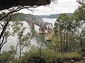 Il ponte della ferrovia di Long island
 Dangar Island (In basso la punta orientale di Long Island)
 Milson Island
 Peat Island
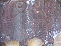 Arte rupestre su Spectacle Island


Note
- (EN) Ku-ring-gai Chase National Park, Lion, Long and Spectacle Island Nature Reserves, Ku-ring-gai Chase Rd, Bobbin Head, NSW, Australia, su environment.gov.au, p. 4. URL consultato il 29 aprile 2018.
- (EN) Long Island - Brooklyn, su hornsby.nsw.gov.au. URL consultato il 30 aprile 2018 (archiviato dall'url originale il 1º maggio 2018).
- Australian Bureau of Statistics, su abs.gov.au. URL consultato il 29 aprile 2018.
- (EN) Sandbrook Inlet, su hornsby.nsw.gov.au. URL consultato il 30 aprile 2018 (archiviato dall'url originale il 1º maggio 2018).
- Dangar Island, su censusdata.abs.gov.au. URL consultato il 30 aprile 2018.
- (EN) Spectacle Island Nature Reserve, Mooney Mooney, NSW, Australia, su environment.gov.au. URL consultato il 30 aprile 2018.
- Jocelyn Powell e Lorraine Banks, Hawkesbury River History - Governor Philip, Exploration and Early Settlement, Dharug and Lower Hawkesbury Historical Society, 1990, p. 13, ISBN 0-7316-8855-4.
- Keith Willey, When the Sky Fell Down - The destruction of the Tribes of the Sydney region 1788-1850s, Collins, 1979, p. 73, ISBN 0-00-216434-5.
Altri progetti
 Wikimedia Commons contiene immagini o altri file su Long Island
На других языках
[en] Long Island (New South Wales)
Long Island is an elongated island of 73 hectares in the Hawkesbury River, about 50 kilometres (31 mi) north of Sydney, New South Wales, Australia. It is joined to the mainland at its south eastern edge by the railway causeway across Sandbrook Inlet. At the other end of this causeway is the Sydney suburb of Brooklyn in Hornsby Shire, to which Long Island belongs.[1]- [it] Long Island (Nuovo Galles del Sud)
Другой контент может иметь иную лицензию. Перед использованием материалов сайта WikiSort.org внимательно изучите правила лицензирования конкретных элементов наполнения сайта.
WikiSort.org - проект по пересортировке и дополнению контента Википедии